You are here: Home > Network List > PR - Puerto Rico Seismic Network (PRSN) & Puerto Rico Strong Motion Program (PRSMP) Stations List
> Station HUMP HUMP > Earthquake Result Viewer
HUMP HUMP - Earthquake Result Viewer
| Earthquake location: |
Andreanof Islands, Aleutian Is. |
| Earthquake latitude/longitude: |
52.4/-176.9 |
| Earthquake time(UTC): |
2023/10/16 (289) 11:35:31 GMT |
| Earthquake Depth: |
187 km |
| Earthquake Magnitude: |
6.4 Mww |
| Earthquake Catalog/Contributor: |
NEIC PDE/us |
|
| Network: |
PR Puerto Rico Seismic Network (PRSN) & Puerto Rico Strong Motion Program (PRSMP) |
| Station: |
HUMP HUMP |
| Lat/Lon: |
18.14 N/65.85 W |
| Elevation: |
80 m |
|
| Distance: |
87.9 deg |
| Az: |
62.662 deg |
| Baz: |
325.123 deg |
| Ray Param: |
0.04253166 |
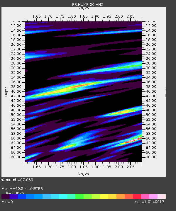
| Estimated Moho Depth: |
60.5 km |
| Estimated Crust Vp/Vs: |
2.06 |
| Assumed Crust Vp: |
5.14 km/s |
| Estimated Crust Vs: |
2.492 km/s |
| Estimated Crust Poisson's Ratio: |
0.35 |
|
| Radial Match: |
87.869 % |
| Radial Bump: |
369 |
| Transverse Match: |
81.412926 % |
| Transverse Bump: |
400 |
| SOD ConfigId: |
31937991 |
| Insert Time: |
2023-10-30 12:31:05.796 +0000 |
| GWidth: |
2.5 |
| Max Bumps: |
400 |
| Tol: |
0.001 |
|

Signal To Noise
| Channel | StoN | STA | LTA |
| PR:HUMP:00:HHZ:20231016T11:47:28.939989Z | 7.0822873 | 1.0078155E-6 | 1.4230086E-7 |
| PR:HUMP:00:HH1:20231016T11:47:28.939989Z | 5.336744 | 4.808277E-7 | 9.009757E-8 |
| PR:HUMP:00:HH2:20231016T11:47:28.939989Z | 2.2182598 | 1.7971281E-7 | 8.101522E-8 |
| Arrivals |
| Ps | 13 SECOND |
| PpPs | 36 SECOND |
| PsPs/PpSs | 48 SECOND |


