You are here: Home > Network List > PR - Puerto Rico Seismic Network (PRSN) & Puerto Rico Strong Motion Program (PRSMP) Stations List
> Station IGPR Inter Guayama > Earthquake Result Viewer
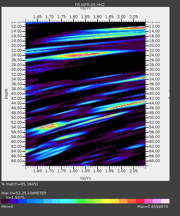
IGPR Inter Guayama - Earthquake Result Viewer
| Earthquake location: |
Andreanof Islands, Aleutian Is. |
| Earthquake latitude/longitude: |
52.4/-176.9 |
| Earthquake time(UTC): |
2023/10/16 (289) 11:35:31 GMT |
| Earthquake Depth: |
187 km |
| Earthquake Magnitude: |
6.4 Mww |
| Earthquake Catalog/Contributor: |
NEIC PDE/us |
|
| Network: |
PR Puerto Rico Seismic Network (PRSN) & Puerto Rico Strong Motion Program (PRSMP) |
| Station: |
IGPR Inter Guayama |
| Lat/Lon: |
17.97 N/66.11 W |
| Elevation: |
10 m |
|
| Distance: |
87.9 deg |
| Az: |
62.964 deg |
| Baz: |
325.055 deg |
| Ray Param: |
0.04252902 |
| Estimated Moho Depth: |
53.25 km |
| Estimated Crust Vp/Vs: |
1.69 |
| Assumed Crust Vp: |
4.082 km/s |
| Estimated Crust Vs: |
2.419 km/s |
| Estimated Crust Poisson's Ratio: |
0.23 |
|
| Radial Match: |
85.36451 % |
| Radial Bump: |
376 |
| Transverse Match: |
86.1799 % |
| Transverse Bump: |
400 |
| SOD ConfigId: |
31937991 |
| Insert Time: |
2023-10-30 12:31:09.186 +0000 |
| GWidth: |
2.5 |
| Max Bumps: |
400 |
| Tol: |
0.001 |
|

Signal To Noise
| Channel | StoN | STA | LTA |
| PR:IGPR:00:HHZ:20231016T11:47:28.949999Z | 10.378693 | 1.2990687E-6 | 1.2516688E-7 |
| PR:IGPR:00:HH1:20231016T11:47:28.949999Z | 2.6689544 | 3.1783006E-7 | 1.19084106E-7 |
| PR:IGPR:00:HH2:20231016T11:47:28.949999Z | 2.178067 | 2.8249602E-7 | 1.2970034E-7 |
| Arrivals |
| Ps | 9.0 SECOND |
| PpPs | 35 SECOND |
| PsPs/PpSs | 44 SECOND |


