You are here: Home > Network List > RV - Regional Alberta Seismic Observatory for Earthquake Studies Network Stations List
> Station REDDA Red Deer Airport, AB > Earthquake Result Viewer
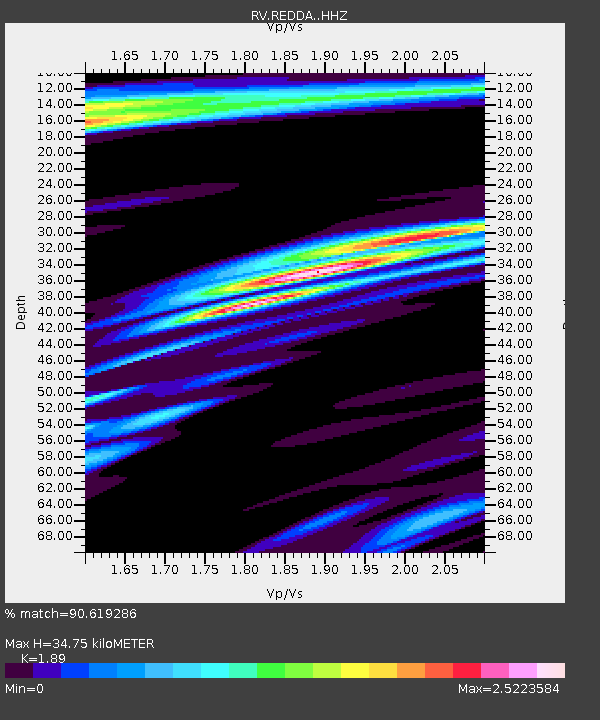
REDDA Red Deer Airport, AB - Earthquake Result Viewer
| Earthquake location: |
Andreanof Islands, Aleutian Is. |
| Earthquake latitude/longitude: |
52.4/-176.9 |
| Earthquake time(UTC): |
2023/10/16 (289) 11:35:31 GMT |
| Earthquake Depth: |
187 km |
| Earthquake Magnitude: |
6.4 Mww |
| Earthquake Catalog/Contributor: |
NEIC PDE/us |
|
| Network: |
RV Regional Alberta Seismic Observatory for Earthquake Studies Network |
| Station: |
REDDA Red Deer Airport, AB |
| Lat/Lon: |
52.18 N/113.90 W |
| Elevation: |
892 m |
|
| Distance: |
37.4 deg |
| Az: |
64.563 deg |
| Baz: |
296.144 deg |
| Ray Param: |
0.07548602 |
| Estimated Moho Depth: |
34.75 km |
| Estimated Crust Vp/Vs: |
1.89 |
| Assumed Crust Vp: |
6.483 km/s |
| Estimated Crust Vs: |
3.43 km/s |
| Estimated Crust Poisson's Ratio: |
0.31 |
|
| Radial Match: |
90.619286 % |
| Radial Bump: |
296 |
| Transverse Match: |
75.80141 % |
| Transverse Bump: |
383 |
| SOD ConfigId: |
31937991 |
| Insert Time: |
2023-10-30 12:32:50.370 +0000 |
| GWidth: |
2.5 |
| Max Bumps: |
400 |
| Tol: |
0.001 |
|

Signal To Noise
| Channel | StoN | STA | LTA |
| RV:REDDA: :HHZ:20231016T11:41:56.020006Z | 23.352007 | 4.30304E-6 | 1.8426854E-7 |
| RV:REDDA: :HHN:20231016T11:41:56.020006Z | 1.4044323 | 7.935769E-7 | 5.650517E-7 |
| RV:REDDA: :HHE:20231016T11:41:56.020006Z | 14.435906 | 4.2731976E-6 | 2.9601173E-7 |
| Arrivals |
| Ps | 5.1 SECOND |
| PpPs | 14 SECOND |
| PsPs/PpSs | 20 SECOND |


