You are here: Home > Network List > RV - Regional Alberta Seismic Observatory for Earthquake Studies Network Stations List
> Station THORA Thorhild, AB > Earthquake Result Viewer
THORA Thorhild, AB - Earthquake Result Viewer
| Earthquake location: |
Andreanof Islands, Aleutian Is. |
| Earthquake latitude/longitude: |
52.4/-176.9 |
| Earthquake time(UTC): |
2023/10/16 (289) 11:35:31 GMT |
| Earthquake Depth: |
187 km |
| Earthquake Magnitude: |
6.4 Mww |
| Earthquake Catalog/Contributor: |
NEIC PDE/us |
|
| Network: |
RV Regional Alberta Seismic Observatory for Earthquake Studies Network |
| Station: |
THORA Thorhild, AB |
| Lat/Lon: |
54.20 N/113.21 W |
| Elevation: |
640 m |
|
| Distance: |
36.9 deg |
| Az: |
61.229 deg |
| Baz: |
294.04 deg |
| Ray Param: |
0.07574643 |
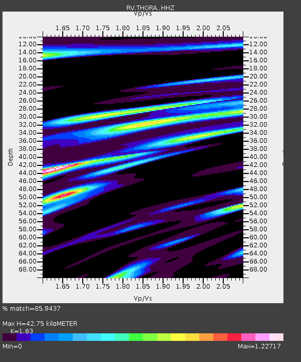
| Estimated Moho Depth: |
42.75 km |
| Estimated Crust Vp/Vs: |
1.63 |
| Assumed Crust Vp: |
6.444 km/s |
| Estimated Crust Vs: |
3.953 km/s |
| Estimated Crust Poisson's Ratio: |
0.20 |
|
| Radial Match: |
85.9437 % |
| Radial Bump: |
384 |
| Transverse Match: |
56.620506 % |
| Transverse Bump: |
400 |
| SOD ConfigId: |
31937991 |
| Insert Time: |
2023-10-30 12:32:56.560 +0000 |
| GWidth: |
2.5 |
| Max Bumps: |
400 |
| Tol: |
0.001 |
|

Signal To Noise
| Channel | StoN | STA | LTA |
| RV:THORA: :HHZ:20231016T11:41:51.969988Z | 18.339754 | 7.208449E-6 | 3.9305047E-7 |
| RV:THORA: :HHN:20231016T11:41:51.969988Z | 3.6660793 | 2.0980385E-6 | 5.72284E-7 |
| RV:THORA: :HHE:20231016T11:41:51.969988Z | 8.014756 | 3.9306815E-6 | 4.904305E-7 |
| Arrivals |
| Ps | 4.5 SECOND |
| PpPs | 16 SECOND |
| PsPs/PpSs | 21 SECOND |


