You are here: Home > Network List > TA - USArray Transportable Network (new EarthScope stations) Stations List
> Station R32A Long Quarter, Great Bend, KS, USA > Earthquake Result Viewer
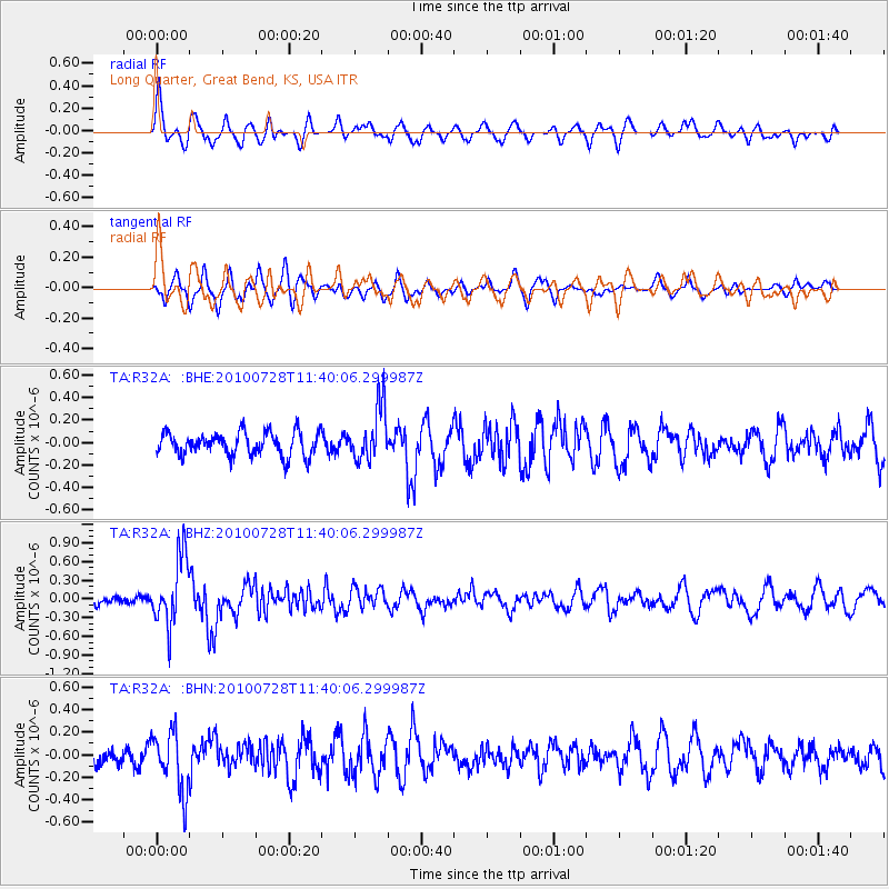
R32A Long Quarter, Great Bend, KS, USA - Earthquake Result Viewer
*The percent match for this event was below the threshold and hence no stack was calculated.
| Earthquake location: |
Fox Islands, Aleutian Islands |
| Earthquake latitude/longitude: |
52.7/-169.4 |
| Earthquake time(UTC): |
2010/07/28 (209) 11:31:46 GMT |
| Earthquake Depth: |
10 km |
| Earthquake Magnitude: |
5.6 MW, 5.2 MS, 5.2 MB, 5.1 ML |
| Earthquake Catalog/Contributor: |
WHDF/NEIC |
|
| Network: |
TA USArray Transportable Network (new EarthScope stations) |
| Station: |
R32A Long Quarter, Great Bend, KS, USA |
| Lat/Lon: |
38.42 N/98.71 W |
| Elevation: |
573 m |
|
| Distance: |
49.5 deg |
| Az: |
77.013 deg |
| Baz: |
310.929 deg |
| Ray Param: |
$rayparam |
*The percent match for this event was below the threshold and hence was not used in the summary stack. |
|
| Radial Match: |
56.57062 % |
| Radial Bump: |
400 |
| Transverse Match: |
55.23363 % |
| Transverse Bump: |
400 |
| SOD ConfigId: |
319893 |
| Insert Time: |
2011-01-05 13:47:37.849 +0000 |
| GWidth: |
2.5 |
| Max Bumps: |
400 |
| Tol: |
0.001 |
|
Signal To Noise
| Channel | StoN | STA | LTA |
| TA:R32A: :BHZ:20100728T11:40:06.299987Z | 8.019812 | 5.451297E-7 | 6.797288E-8 |
| TA:R32A: :BHN:20100728T11:40:06.299987Z | 3.936967 | 2.6537901E-7 | 6.740697E-8 |
| TA:R32A: :BHE:20100728T11:40:06.299987Z | 2.3121011 | 2.4051792E-7 | 1.04025695E-7 |
| Arrivals |
| Ps | |
| PpPs | |
| PsPs/PpSs | |


