You are here: Home > Network List > TM - Thai Seismic Monitoring Network Stations List
> Station NAYO Khun Dan Dam, Nakhon Nayok > Earthquake Result Viewer
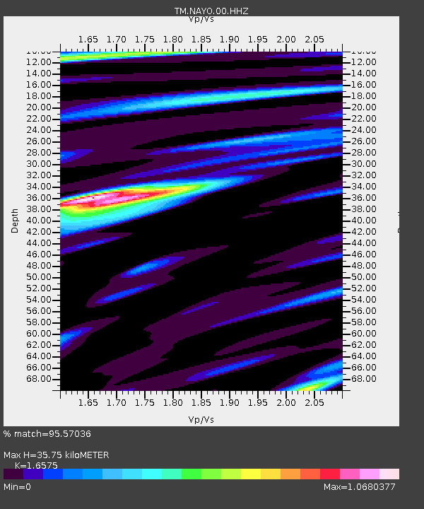
NAYO Khun Dan Dam, Nakhon Nayok - Earthquake Result Viewer
| Earthquake location: |
Andreanof Islands, Aleutian Is. |
| Earthquake latitude/longitude: |
52.4/-176.9 |
| Earthquake time(UTC): |
2023/10/16 (289) 11:35:31 GMT |
| Earthquake Depth: |
187 km |
| Earthquake Magnitude: |
6.4 Mww |
| Earthquake Catalog/Contributor: |
NEIC PDE/us |
|
| Network: |
TM Thai Seismic Monitoring Network |
| Station: |
NAYO Khun Dan Dam, Nakhon Nayok |
| Lat/Lon: |
14.32 N/101.32 E |
| Elevation: |
106 m |
|
| Distance: |
73.8 deg |
| Az: |
272.473 deg |
| Baz: |
39.114 deg |
| Ray Param: |
0.05225798 |
| Estimated Moho Depth: |
35.75 km |
| Estimated Crust Vp/Vs: |
1.66 |
| Assumed Crust Vp: |
6.498 km/s |
| Estimated Crust Vs: |
3.92 km/s |
| Estimated Crust Poisson's Ratio: |
0.21 |
|
| Radial Match: |
95.57036 % |
| Radial Bump: |
266 |
| Transverse Match: |
78.70513 % |
| Transverse Bump: |
400 |
| SOD ConfigId: |
31937991 |
| Insert Time: |
2023-10-30 12:34:55.494 +0000 |
| GWidth: |
2.5 |
| Max Bumps: |
400 |
| Tol: |
0.001 |
|

Signal To Noise
| Channel | StoN | STA | LTA |
| TM:NAYO:00:HHZ:20231016T11:46:14.660021Z | 23.10715 | 2.650485E-6 | 1.1470411E-7 |
| TM:NAYO:00:HHN:20231016T11:46:14.660021Z | 12.471461 | 8.2090435E-7 | 6.5822626E-8 |
| TM:NAYO:00:HHE:20231016T11:46:14.660021Z | 8.327351 | 5.9490014E-7 | 7.143931E-8 |
| Arrivals |
| Ps | 3.8 SECOND |
| PpPs | 14 SECOND |
| PsPs/PpSs | 18 SECOND |


