You are here: Home > Network List > TX - Texas Seismological Network Stations List
> Station MB10 Stanton > Earthquake Result Viewer
MB10 Stanton - Earthquake Result Viewer
| Earthquake location: |
Andreanof Islands, Aleutian Is. |
| Earthquake latitude/longitude: |
52.4/-176.9 |
| Earthquake time(UTC): |
2023/10/16 (289) 11:35:31 GMT |
| Earthquake Depth: |
187 km |
| Earthquake Magnitude: |
6.4 Mww |
| Earthquake Catalog/Contributor: |
NEIC PDE/us |
|
| Network: |
TX Texas Seismological Network |
| Station: |
MB10 Stanton |
| Lat/Lon: |
32.27 N/101.79 W |
| Elevation: |
813 m |
|
| Distance: |
56.4 deg |
| Az: |
79.45 deg |
| Baz: |
314.742 deg |
| Ray Param: |
0.063570455 |
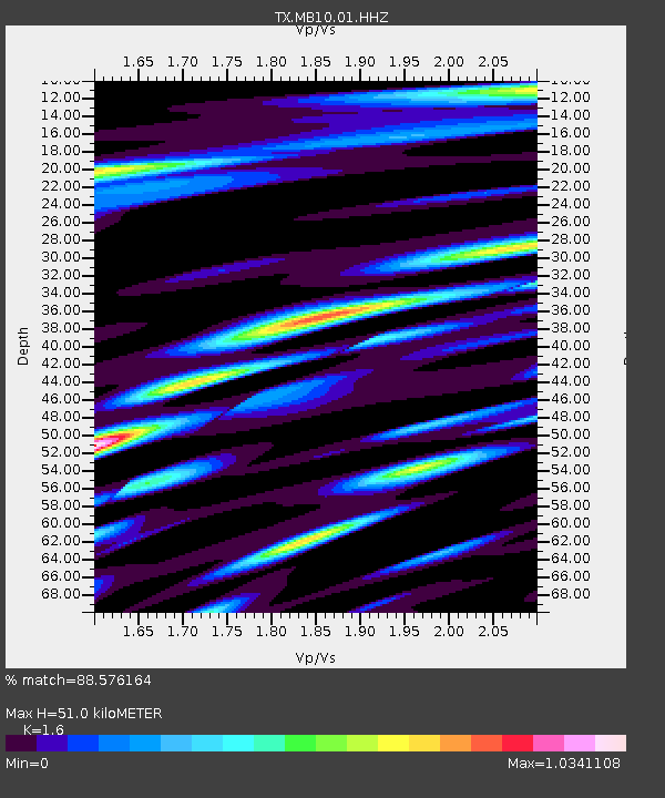
| Estimated Moho Depth: |
51.0 km |
| Estimated Crust Vp/Vs: |
1.60 |
| Assumed Crust Vp: |
6.426 km/s |
| Estimated Crust Vs: |
4.016 km/s |
| Estimated Crust Poisson's Ratio: |
0.18 |
|
| Radial Match: |
88.576164 % |
| Radial Bump: |
400 |
| Transverse Match: |
73.378975 % |
| Transverse Bump: |
400 |
| SOD ConfigId: |
31937991 |
| Insert Time: |
2023-10-30 12:35:46.144 +0000 |
| GWidth: |
2.5 |
| Max Bumps: |
400 |
| Tol: |
0.001 |
|

Signal To Noise
| Channel | StoN | STA | LTA |
| TX:MB10:01:HHZ:20231016T11:44:22.624987Z | 30.767782 | 6.4025508E-6 | 2.080927E-7 |
| TX:MB10:01:HHN:20231016T11:44:22.624987Z | 6.544897 | 1.7156084E-6 | 2.6212916E-7 |
| TX:MB10:01:HHE:20231016T11:44:22.624987Z | 7.511031 | 2.130832E-6 | 2.8369368E-7 |
| Arrivals |
| Ps | 5.0 SECOND |
| PpPs | 20 SECOND |
| PsPs/PpSs | 25 SECOND |


