You are here: Home > Network List > TA - USArray Transportable Network (new EarthScope stations) Stations List
> Station Z35A Perchaven, Sanger, TX, USA > Earthquake Result Viewer
Z35A Perchaven, Sanger, TX, USA - Earthquake Result Viewer
| Earthquake location: |
Fox Islands, Aleutian Islands |
| Earthquake latitude/longitude: |
52.7/-169.4 |
| Earthquake time(UTC): |
2010/07/28 (209) 11:31:46 GMT |
| Earthquake Depth: |
10 km |
| Earthquake Magnitude: |
5.6 MW, 5.2 MS, 5.2 MB, 5.1 ML |
| Earthquake Catalog/Contributor: |
WHDF/NEIC |
|
| Network: |
TA USArray Transportable Network (new EarthScope stations) |
| Station: |
Z35A Perchaven, Sanger, TX, USA |
| Lat/Lon: |
33.33 N/97.25 W |
| Elevation: |
235 m |
|
| Distance: |
53.8 deg |
| Az: |
80.764 deg |
| Baz: |
314.109 deg |
| Ray Param: |
0.065829396 |
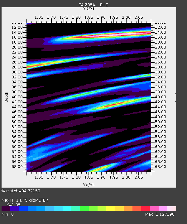
| Estimated Moho Depth: |
14.75 km |
| Estimated Crust Vp/Vs: |
1.95 |
| Assumed Crust Vp: |
6.38 km/s |
| Estimated Crust Vs: |
3.272 km/s |
| Estimated Crust Poisson's Ratio: |
0.32 |
|
| Radial Match: |
84.77158 % |
| Radial Bump: |
400 |
| Transverse Match: |
68.49539 % |
| Transverse Bump: |
400 |
| SOD ConfigId: |
319893 |
| Insert Time: |
2011-01-05 13:48:47.778 +0000 |
| GWidth: |
2.5 |
| Max Bumps: |
400 |
| Tol: |
0.001 |
|
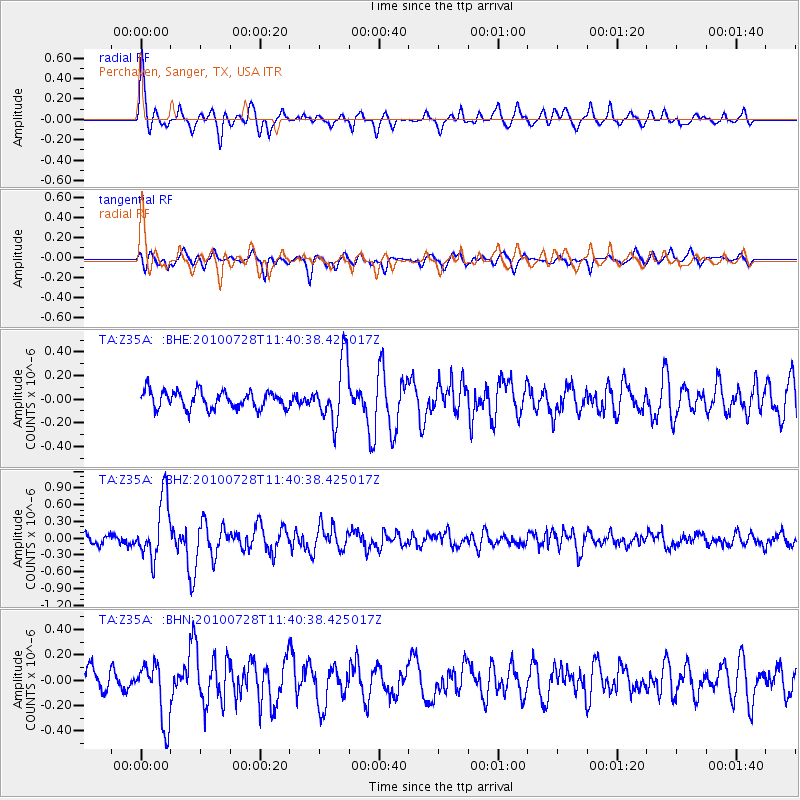
Signal To Noise
| Channel | StoN | STA | LTA |
| TA:Z35A: :BHZ:20100728T11:40:38.425017Z | 5.3011384 | 5.3212403E-7 | 1.0037919E-7 |
| TA:Z35A: :BHN:20100728T11:40:38.425017Z | 3.0146246 | 2.3642878E-7 | 7.842727E-8 |
| TA:Z35A: :BHE:20100728T11:40:38.425017Z | 3.547893 | 2.587776E-7 | 7.2938384E-8 |
| Arrivals |
| Ps | 2.3 SECOND |
| PpPs | 6.5 SECOND |
| PsPs/PpSs | 8.8 SECOND |


