You are here: Home > Network List > TX - Texas Seismological Network Stations List
> Station PB10 Southeast of Toyah > Earthquake Result Viewer
PB10 Southeast of Toyah - Earthquake Result Viewer
| Earthquake location: |
Andreanof Islands, Aleutian Is. |
| Earthquake latitude/longitude: |
52.4/-176.9 |
| Earthquake time(UTC): |
2023/10/16 (289) 11:35:31 GMT |
| Earthquake Depth: |
187 km |
| Earthquake Magnitude: |
6.4 Mww |
| Earthquake Catalog/Contributor: |
NEIC PDE/us |
|
| Network: |
TX Texas Seismological Network |
| Station: |
PB10 Southeast of Toyah |
| Lat/Lon: |
31.28 N/103.75 W |
| Elevation: |
858 m |
|
| Distance: |
55.9 deg |
| Az: |
81.705 deg |
| Baz: |
314.971 deg |
| Ray Param: |
0.063881636 |
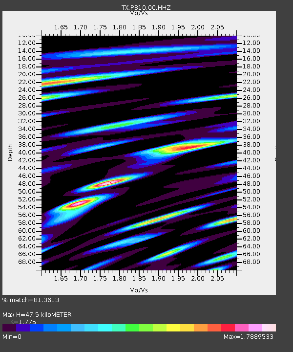
| Estimated Moho Depth: |
47.5 km |
| Estimated Crust Vp/Vs: |
1.77 |
| Assumed Crust Vp: |
6.121 km/s |
| Estimated Crust Vs: |
3.448 km/s |
| Estimated Crust Poisson's Ratio: |
0.27 |
|
| Radial Match: |
81.3613 % |
| Radial Bump: |
400 |
| Transverse Match: |
73.838905 % |
| Transverse Bump: |
400 |
| SOD ConfigId: |
31937991 |
| Insert Time: |
2023-10-30 12:36:06.857 +0000 |
| GWidth: |
2.5 |
| Max Bumps: |
400 |
| Tol: |
0.001 |
|

Signal To Noise
| Channel | StoN | STA | LTA |
| TX:PB10:00:HHZ:20231016T11:44:19.129992Z | 14.722733 | 6.969858E-6 | 4.7340794E-7 |
| TX:PB10:00:HH1:20231016T11:44:19.129992Z | 14.097692 | 2.8993854E-6 | 2.0566385E-7 |
| TX:PB10:00:HH2:20231016T11:44:19.129992Z | 8.813986 | 3.3453036E-6 | 3.7954496E-7 |
| Arrivals |
| Ps | 6.3 SECOND |
| PpPs | 21 SECOND |
| PsPs/PpSs | 27 SECOND |


