You are here: Home > Network List > TX - Texas Seismological Network Stations List
> Station PLPT Palo Pinto > Earthquake Result Viewer
PLPT Palo Pinto - Earthquake Result Viewer
| Earthquake location: |
Andreanof Islands, Aleutian Is. |
| Earthquake latitude/longitude: |
52.4/-176.9 |
| Earthquake time(UTC): |
2023/10/16 (289) 11:35:31 GMT |
| Earthquake Depth: |
187 km |
| Earthquake Magnitude: |
6.4 Mww |
| Earthquake Catalog/Contributor: |
NEIC PDE/us |
|
| Network: |
TX Texas Seismological Network |
| Station: |
PLPT Palo Pinto |
| Lat/Lon: |
32.81 N/98.32 W |
| Elevation: |
336 m |
|
| Distance: |
58.1 deg |
| Az: |
76.525 deg |
| Baz: |
315.019 deg |
| Ray Param: |
0.062479444 |
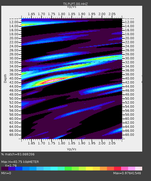
| Estimated Moho Depth: |
40.75 km |
| Estimated Crust Vp/Vs: |
1.76 |
| Assumed Crust Vp: |
6.426 km/s |
| Estimated Crust Vs: |
3.651 km/s |
| Estimated Crust Poisson's Ratio: |
0.26 |
|
| Radial Match: |
93.869286 % |
| Radial Bump: |
333 |
| Transverse Match: |
88.25389 % |
| Transverse Bump: |
400 |
| SOD ConfigId: |
31937991 |
| Insert Time: |
2023-10-30 12:36:28.048 +0000 |
| GWidth: |
2.5 |
| Max Bumps: |
400 |
| Tol: |
0.001 |
|

Signal To Noise
| Channel | StoN | STA | LTA |
| TX:PLPT:00:HHZ:20231016T11:44:34.470019Z | 27.808578 | 6.6462617E-6 | 2.390004E-7 |
| TX:PLPT:00:HH1:20231016T11:44:34.470019Z | 10.368004 | 2.1015678E-6 | 2.0269744E-7 |
| TX:PLPT:00:HH2:20231016T11:44:34.470019Z | 14.317841 | 2.6983353E-6 | 1.8845965E-7 |
| Arrivals |
| Ps | 5.1 SECOND |
| PpPs | 17 SECOND |
| PsPs/PpSs | 22 SECOND |


