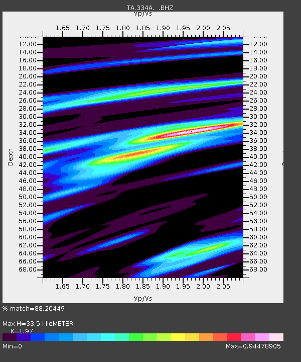
334A Lometa, TX, USA - Earthquake Result Viewer
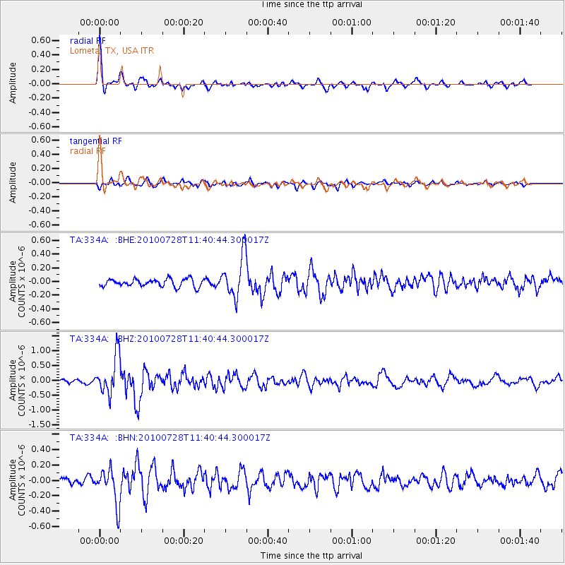
Earthquake location: Fox Islands, Aleutian Islands
Earthquake latitude/longitude: 52.7/-169.4
Earthquake time(UTC): 2010/07/28 (209) 11:31:46 GMT
Earthquake Depth: 10 km
Earthquake Magnitude: 5.6 MW, 5.2 MS, 5.2 MB, 5.1 ML
Earthquake Catalog/Contributor: WHDF/NEIC
Network: TA USArray Transportable Network (new EarthScope stations)
Station: 334A Lometa, TX, USA
Lat/Lon: 31.33 N/98.24 W
Elevation: 389 m
Distance: 54.6 deg
Az: 83.234 deg
Baz: 315.028 deg
Ray Param: 0.06531815
Estimated Moho Depth: 33.5 km
Estimated Crust Vp/Vs: 1.97
Assumed Crust Vp: 6.498 km/s
Estimated Crust Vs: 3.298 km/s
Estimated Crust Poisson's Ratio: 0.33
Radial Match: 88.20449 %
Radial Bump: 400
Transverse Match: 62.97157 %
Transverse Bump: 400
SOD ConfigId: 319893
Insert Time: 2011-01-05 13:49:11.575 +0000
GWidth: 2.5
Max Bumps: 400
Tol: 0.001

Signal To Noise

ChannelStoNSTALTA
TA:334A: :BHZ:20100728T11:40:44.300017Z12.9780636.6859377E-75.151723E-8
TA:334A: :BHN:20100728T11:40:44.300017Z4.2779122.396928E-75.6030323E-8
TA:334A: :BHE:20100728T11:40:44.300017Z5.5358113.1242902E-75.6437806E-8
Arrivals
Ps5.2 SECOND
PpPs15 SECOND
PsPs/PpSs20 SECOND