You are here: Home > Network List > UO - University of Oregon Regional Network Stations List
> Station HBUG Ophir, OR, USA > Earthquake Result Viewer
HBUG Ophir, OR, USA - Earthquake Result Viewer
| Earthquake location: |
Andreanof Islands, Aleutian Is. |
| Earthquake latitude/longitude: |
52.4/-176.9 |
| Earthquake time(UTC): |
2023/10/16 (289) 11:35:31 GMT |
| Earthquake Depth: |
187 km |
| Earthquake Magnitude: |
6.4 Mww |
| Earthquake Catalog/Contributor: |
NEIC PDE/us |
|
| Network: |
UO University of Oregon Regional Network |
| Station: |
HBUG Ophir, OR, USA |
| Lat/Lon: |
42.64 N/124.38 W |
| Elevation: |
388 m |
|
| Distance: |
36.0 deg |
| Az: |
84.37 deg |
| Baz: |
304.356 deg |
| Ray Param: |
0.07624654 |
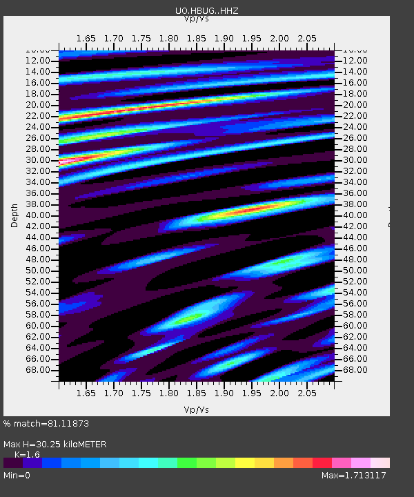
| Estimated Moho Depth: |
30.25 km |
| Estimated Crust Vp/Vs: |
1.60 |
| Assumed Crust Vp: |
6.048 km/s |
| Estimated Crust Vs: |
3.78 km/s |
| Estimated Crust Poisson's Ratio: |
0.18 |
|
| Radial Match: |
81.11873 % |
| Radial Bump: |
387 |
| Transverse Match: |
69.01918 % |
| Transverse Bump: |
400 |
| SOD ConfigId: |
31937991 |
| Insert Time: |
2023-10-30 12:38:10.594 +0000 |
| GWidth: |
2.5 |
| Max Bumps: |
400 |
| Tol: |
0.001 |
|

Signal To Noise
| Channel | StoN | STA | LTA |
| UO:HBUG: :HHZ:20231016T11:41:44.43001Z | 15.603639 | 1.7327524E-5 | 1.1104797E-6 |
| UO:HBUG: :HHN:20231016T11:41:44.43001Z | 5.9098897 | 5.5053697E-6 | 9.31552E-7 |
| UO:HBUG: :HHE:20231016T11:41:44.43001Z | 4.4593554 | 7.833199E-6 | 1.7565765E-6 |
| Arrivals |
| Ps | 3.2 SECOND |
| PpPs | 12 SECOND |
| PsPs/PpSs | 15 SECOND |


