You are here: Home > Network List > UO - University of Oregon Regional Network Stations List
> Station LONE Glide, OR, USA > Earthquake Result Viewer
LONE Glide, OR, USA - Earthquake Result Viewer
| Earthquake location: |
Andreanof Islands, Aleutian Is. |
| Earthquake latitude/longitude: |
52.4/-176.9 |
| Earthquake time(UTC): |
2023/10/16 (289) 11:35:31 GMT |
| Earthquake Depth: |
187 km |
| Earthquake Magnitude: |
6.4 Mww |
| Earthquake Catalog/Contributor: |
NEIC PDE/us |
|
| Network: |
UO University of Oregon Regional Network |
| Station: |
LONE Glide, OR, USA |
| Lat/Lon: |
43.36 N/123.06 W |
| Elevation: |
1226 m |
|
| Distance: |
36.4 deg |
| Az: |
82.439 deg |
| Baz: |
303.696 deg |
| Ray Param: |
0.07601763 |
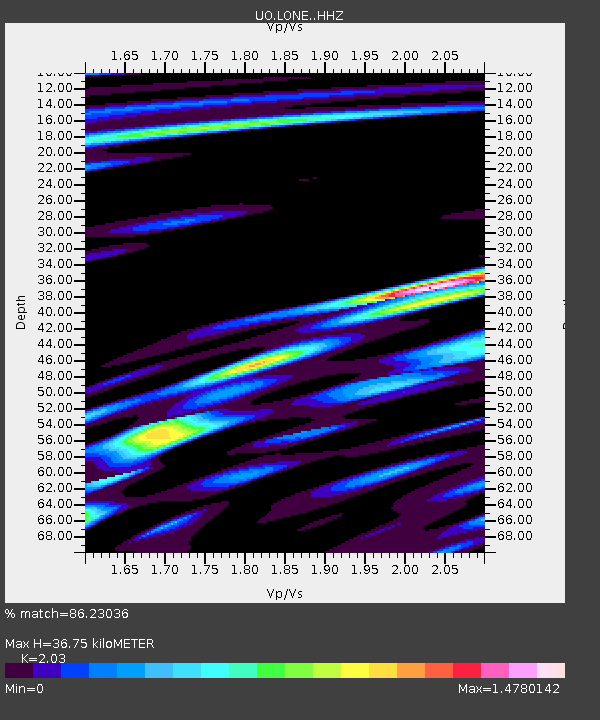
| Estimated Moho Depth: |
36.75 km |
| Estimated Crust Vp/Vs: |
2.03 |
| Assumed Crust Vp: |
6.522 km/s |
| Estimated Crust Vs: |
3.213 km/s |
| Estimated Crust Poisson's Ratio: |
0.34 |
|
| Radial Match: |
86.23036 % |
| Radial Bump: |
400 |
| Transverse Match: |
65.122894 % |
| Transverse Bump: |
400 |
| SOD ConfigId: |
31937991 |
| Insert Time: |
2023-10-30 12:38:29.104 +0000 |
| GWidth: |
2.5 |
| Max Bumps: |
400 |
| Tol: |
0.001 |
|

Signal To Noise
| Channel | StoN | STA | LTA |
| UO:LONE: :HHZ:20231016T11:41:47.810015Z | 25.510267 | 1.4858878E-5 | 5.8246655E-7 |
| UO:LONE: :HHN:20231016T11:41:47.810015Z | 6.935953 | 4.1568815E-6 | 5.9932376E-7 |
| UO:LONE: :HHE:20231016T11:41:47.810015Z | 11.441185 | 6.9654193E-6 | 6.088022E-7 |
| Arrivals |
| Ps | 6.2 SECOND |
| PpPs | 16 SECOND |
| PsPs/PpSs | 22 SECOND |


