You are here: Home > Network List > TA - USArray Transportable Network (new EarthScope stations) Stations List
> Station 339A Huntington, TX, USA > Earthquake Result Viewer
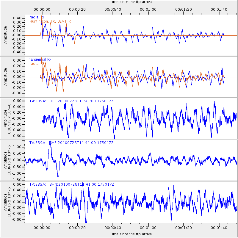
339A Huntington, TX, USA - Earthquake Result Viewer
*The percent match for this event was below the threshold and hence no stack was calculated.
| Earthquake location: |
Fox Islands, Aleutian Islands |
| Earthquake latitude/longitude: |
52.7/-169.4 |
| Earthquake time(UTC): |
2010/07/28 (209) 11:31:46 GMT |
| Earthquake Depth: |
10 km |
| Earthquake Magnitude: |
5.6 MW, 5.2 MS, 5.2 MB, 5.1 ML |
| Earthquake Catalog/Contributor: |
WHDF/NEIC |
|
| Network: |
TA USArray Transportable Network (new EarthScope stations) |
| Station: |
339A Huntington, TX, USA |
| Lat/Lon: |
31.33 N/94.56 W |
| Elevation: |
82 m |
|
| Distance: |
56.9 deg |
| Az: |
80.529 deg |
| Baz: |
315.411 deg |
| Ray Param: |
$rayparam |
*The percent match for this event was below the threshold and hence was not used in the summary stack. |
|
| Radial Match: |
64.27636 % |
| Radial Bump: |
400 |
| Transverse Match: |
56.278503 % |
| Transverse Bump: |
334 |
| SOD ConfigId: |
319893 |
| Insert Time: |
2011-01-05 13:50:52.467 +0000 |
| GWidth: |
2.5 |
| Max Bumps: |
400 |
| Tol: |
0.001 |
|
Signal To Noise
| Channel | StoN | STA | LTA |
| TA:339A: :BHZ:20100728T11:41:00.175017Z | 4.4288 | 6.415789E-7 | 1.4486517E-7 |
| TA:339A: :BHN:20100728T11:41:00.175017Z | 1.040472 | 1.9699114E-7 | 1.8932862E-7 |
| TA:339A: :BHE:20100728T11:41:00.175017Z | 0.85664356 | 1.9351914E-7 | 2.2590393E-7 |
| Arrivals |
| Ps | |
| PpPs | |
| PsPs/PpSs | |


