You are here: Home > Network List > US - United States National Seismic Network Stations List
> Station LAO LASA Array, Montana, USA > Earthquake Result Viewer
LAO LASA Array, Montana, USA - Earthquake Result Viewer
| Earthquake location: |
Andreanof Islands, Aleutian Is. |
| Earthquake latitude/longitude: |
52.4/-176.9 |
| Earthquake time(UTC): |
2023/10/16 (289) 11:35:31 GMT |
| Earthquake Depth: |
187 km |
| Earthquake Magnitude: |
6.4 Mww |
| Earthquake Catalog/Contributor: |
NEIC PDE/us |
|
| Network: |
US United States National Seismic Network |
| Station: |
LAO LASA Array, Montana, USA |
| Lat/Lon: |
46.69 N/106.22 W |
| Elevation: |
902 m |
|
| Distance: |
44.5 deg |
| Az: |
67.923 deg |
| Baz: |
304.516 deg |
| Ray Param: |
0.07116696 |
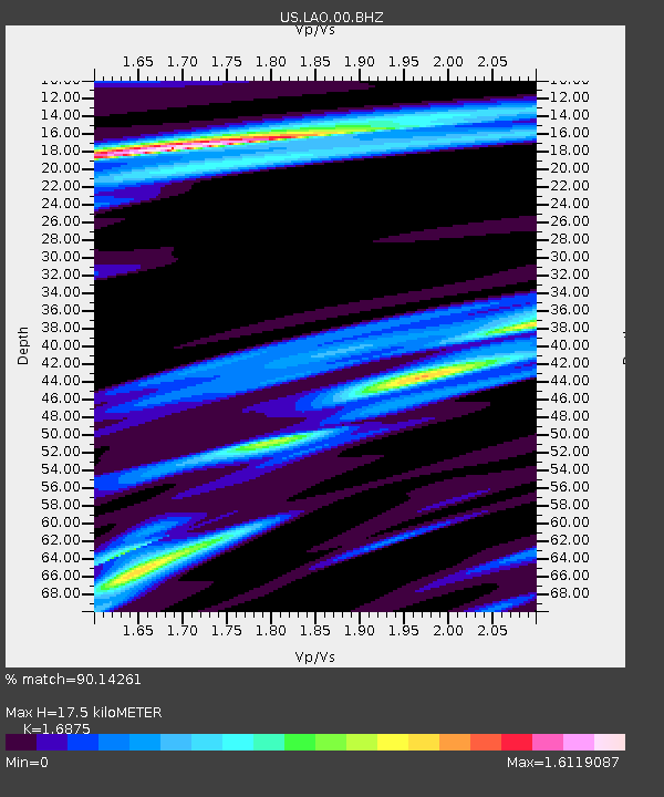
| Estimated Moho Depth: |
17.5 km |
| Estimated Crust Vp/Vs: |
1.69 |
| Assumed Crust Vp: |
6.438 km/s |
| Estimated Crust Vs: |
3.815 km/s |
| Estimated Crust Poisson's Ratio: |
0.23 |
|
| Radial Match: |
90.14261 % |
| Radial Bump: |
400 |
| Transverse Match: |
77.15404 % |
| Transverse Bump: |
400 |
| SOD ConfigId: |
31937991 |
| Insert Time: |
2023-10-30 12:40:22.706 +0000 |
| GWidth: |
2.5 |
| Max Bumps: |
400 |
| Tol: |
0.001 |
|

Signal To Noise
| Channel | StoN | STA | LTA |
| US:LAO:00:BHZ:20231016T11:42:53.849993Z | 35.63953 | 9.375917E-6 | 2.6307634E-7 |
| US:LAO:00:BH1:20231016T11:42:53.849993Z | 3.426577 | 1.638523E-6 | 4.781807E-7 |
| US:LAO:00:BH2:20231016T11:42:53.849993Z | 7.8224554 | 3.902364E-6 | 4.988669E-7 |
| Arrivals |
| Ps | 2.0 SECOND |
| PpPs | 6.8 SECOND |
| PsPs/PpSs | 8.8 SECOND |


