You are here: Home > Network List > UU - University of Utah Regional Network Stations List
> Station FOR6 FORGE > Earthquake Result Viewer
FOR6 FORGE - Earthquake Result Viewer
| Earthquake location: |
Andreanof Islands, Aleutian Is. |
| Earthquake latitude/longitude: |
52.4/-176.9 |
| Earthquake time(UTC): |
2023/10/16 (289) 11:35:31 GMT |
| Earthquake Depth: |
187 km |
| Earthquake Magnitude: |
6.4 Mww |
| Earthquake Catalog/Contributor: |
NEIC PDE/us |
|
| Network: |
UU University of Utah Regional Network |
| Station: |
FOR6 FORGE |
| Lat/Lon: |
38.49 N/112.79 W |
| Elevation: |
2421 m |
|
| Distance: |
45.6 deg |
| Az: |
81.302 deg |
| Baz: |
309.554 deg |
| Ray Param: |
0.07050826 |
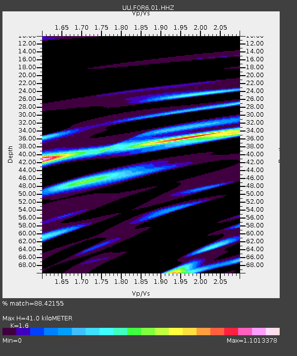
| Estimated Moho Depth: |
41.0 km |
| Estimated Crust Vp/Vs: |
1.60 |
| Assumed Crust Vp: |
6.276 km/s |
| Estimated Crust Vs: |
3.922 km/s |
| Estimated Crust Poisson's Ratio: |
0.18 |
|
| Radial Match: |
88.42155 % |
| Radial Bump: |
400 |
| Transverse Match: |
77.80429 % |
| Transverse Bump: |
400 |
| SOD ConfigId: |
31937991 |
| Insert Time: |
2023-10-30 12:41:07.627 +0000 |
| GWidth: |
2.5 |
| Max Bumps: |
400 |
| Tol: |
0.001 |
|

Signal To Noise
| Channel | StoN | STA | LTA |
| UU:FOR6:01:HHZ:20231016T11:43:02.210009Z | 51.801422 | 1.0354463E-5 | 1.9988761E-7 |
| UU:FOR6:01:HHN:20231016T11:43:02.210009Z | 26.454905 | 7.130887E-6 | 2.6954876E-7 |
| UU:FOR6:01:HHE:20231016T11:43:02.210009Z | 11.743032 | 3.8038786E-6 | 3.2392646E-7 |
| Arrivals |
| Ps | 4.2 SECOND |
| PpPs | 16 SECOND |
| PsPs/PpSs | 20 SECOND |


