You are here: Home > Network List > UW - Pacific Northwest Regional Seismic Network Stations List
> Station CDF Cedar Flats, MSH, WA, USA > Earthquake Result Viewer
CDF Cedar Flats, MSH, WA, USA - Earthquake Result Viewer
| Earthquake location: |
Andreanof Islands, Aleutian Is. |
| Earthquake latitude/longitude: |
52.4/-176.9 |
| Earthquake time(UTC): |
2023/10/16 (289) 11:35:31 GMT |
| Earthquake Depth: |
187 km |
| Earthquake Magnitude: |
6.4 Mww |
| Earthquake Catalog/Contributor: |
NEIC PDE/us |
|
| Network: |
UW Pacific Northwest Regional Seismic Network |
| Station: |
CDF Cedar Flats, MSH, WA, USA |
| Lat/Lon: |
46.12 N/122.05 W |
| Elevation: |
772 m |
|
| Distance: |
35.6 deg |
| Az: |
77.819 deg |
| Baz: |
300.667 deg |
| Ray Param: |
0.07650487 |
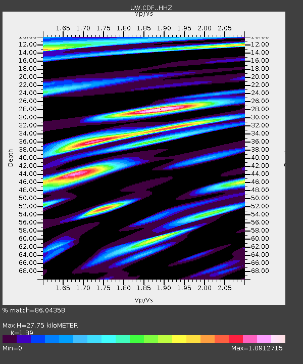
| Estimated Moho Depth: |
27.75 km |
| Estimated Crust Vp/Vs: |
1.89 |
| Assumed Crust Vp: |
6.566 km/s |
| Estimated Crust Vs: |
3.474 km/s |
| Estimated Crust Poisson's Ratio: |
0.31 |
|
| Radial Match: |
86.04358 % |
| Radial Bump: |
400 |
| Transverse Match: |
70.46815 % |
| Transverse Bump: |
400 |
| SOD ConfigId: |
31937991 |
| Insert Time: |
2023-10-30 12:42:06.901 +0000 |
| GWidth: |
2.5 |
| Max Bumps: |
400 |
| Tol: |
0.001 |
|

Signal To Noise
| Channel | StoN | STA | LTA |
| UW:CDF: :HHZ:20231016T11:41:40.550005Z | 52.095924 | 1.2753698E-5 | 2.4481182E-7 |
| UW:CDF: :HHN:20231016T11:41:40.550005Z | 9.906262 | 3.3373874E-6 | 3.3689676E-7 |
| UW:CDF: :HHE:20231016T11:41:40.550005Z | 20.361698 | 7.502589E-6 | 3.684658E-7 |
| Arrivals |
| Ps | 4.0 SECOND |
| PpPs | 11 SECOND |
| PsPs/PpSs | 15 SECOND |


