You are here: Home > Network List > UW - Pacific Northwest Regional Seismic Network Stations List
> Station KTSAP Belfair, WA, USA > Earthquake Result Viewer
KTSAP Belfair, WA, USA - Earthquake Result Viewer
| Earthquake location: |
Andreanof Islands, Aleutian Is. |
| Earthquake latitude/longitude: |
52.4/-176.9 |
| Earthquake time(UTC): |
2023/10/16 (289) 11:35:31 GMT |
| Earthquake Depth: |
187 km |
| Earthquake Magnitude: |
6.4 Mww |
| Earthquake Catalog/Contributor: |
NEIC PDE/us |
|
| Network: |
UW Pacific Northwest Regional Seismic Network |
| Station: |
KTSAP Belfair, WA, USA |
| Lat/Lon: |
47.52 N/122.94 W |
| Elevation: |
167 m |
|
| Distance: |
34.3 deg |
| Az: |
76.223 deg |
| Baz: |
298.71 deg |
| Ray Param: |
0.07713653 |
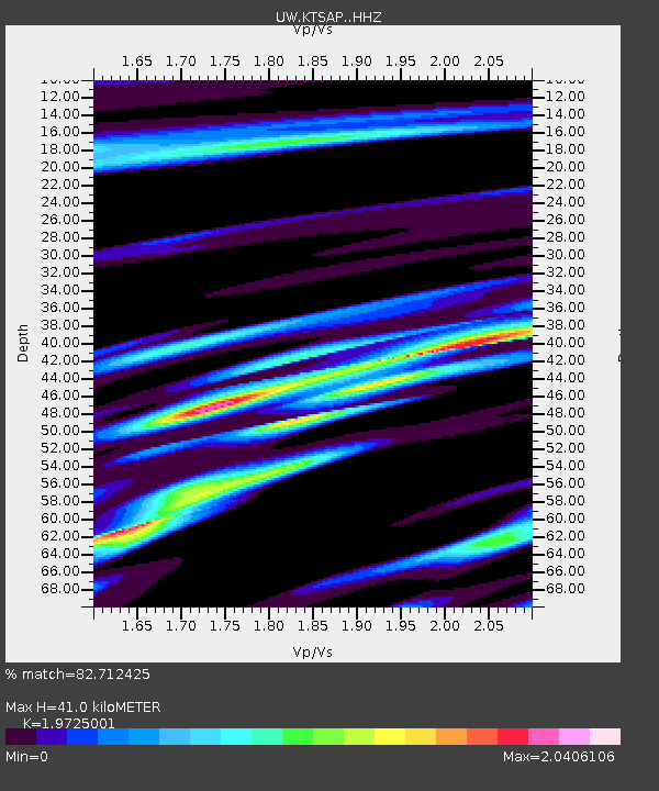
| Estimated Moho Depth: |
41.0 km |
| Estimated Crust Vp/Vs: |
1.97 |
| Assumed Crust Vp: |
6.566 km/s |
| Estimated Crust Vs: |
3.329 km/s |
| Estimated Crust Poisson's Ratio: |
0.33 |
|
| Radial Match: |
82.712425 % |
| Radial Bump: |
320 |
| Transverse Match: |
74.26263 % |
| Transverse Bump: |
400 |
| SOD ConfigId: |
31937991 |
| Insert Time: |
2023-10-30 12:43:25.737 +0000 |
| GWidth: |
2.5 |
| Max Bumps: |
400 |
| Tol: |
0.001 |
|

Signal To Noise
| Channel | StoN | STA | LTA |
| UW:KTSAP: :HHZ:20231016T11:41:30.080004Z | 24.110388 | 1.5038992E-5 | 6.2375574E-7 |
| UW:KTSAP: :HHN:20231016T11:41:30.080004Z | 5.1669216 | 3.7444079E-6 | 7.246884E-7 |
| UW:KTSAP: :HHE:20231016T11:41:30.080004Z | 7.754123 | 7.961115E-6 | 1.0266945E-6 |
| Arrivals |
| Ps | 6.5 SECOND |
| PpPs | 17 SECOND |
| PsPs/PpSs | 24 SECOND |


