You are here: Home > Network List > UW - Pacific Northwest Regional Seismic Network Stations List
> Station LTY Liberty (broad-band) > Earthquake Result Viewer
LTY Liberty (broad-band) - Earthquake Result Viewer
| Earthquake location: |
Andreanof Islands, Aleutian Is. |
| Earthquake latitude/longitude: |
52.4/-176.9 |
| Earthquake time(UTC): |
2023/10/16 (289) 11:35:31 GMT |
| Earthquake Depth: |
187 km |
| Earthquake Magnitude: |
6.4 Mww |
| Earthquake Catalog/Contributor: |
NEIC PDE/us |
|
| Network: |
UW Pacific Northwest Regional Seismic Network |
| Station: |
LTY Liberty (broad-band) |
| Lat/Lon: |
47.26 N/120.66 W |
| Elevation: |
970 m |
|
| Distance: |
35.8 deg |
| Az: |
75.311 deg |
| Baz: |
299.632 deg |
| Ray Param: |
0.07636467 |
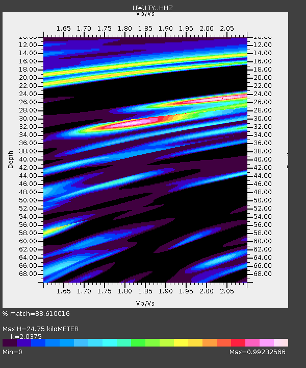
| Estimated Moho Depth: |
24.75 km |
| Estimated Crust Vp/Vs: |
2.04 |
| Assumed Crust Vp: |
6.597 km/s |
| Estimated Crust Vs: |
3.238 km/s |
| Estimated Crust Poisson's Ratio: |
0.34 |
|
| Radial Match: |
88.610016 % |
| Radial Bump: |
360 |
| Transverse Match: |
73.50129 % |
| Transverse Bump: |
400 |
| SOD ConfigId: |
31937991 |
| Insert Time: |
2023-10-30 12:43:45.270 +0000 |
| GWidth: |
2.5 |
| Max Bumps: |
400 |
| Tol: |
0.001 |
|

Signal To Noise
| Channel | StoN | STA | LTA |
| UW:LTY: :HHZ:20231016T11:41:42.670Z | 20.688803 | 6.3717407E-6 | 3.0798014E-7 |
| UW:LTY: :HHN:20231016T11:41:42.670Z | 5.0906734 | 1.8680187E-6 | 3.6694922E-7 |
| UW:LTY: :HHE:20231016T11:41:42.670Z | 7.6962895 | 2.6031184E-6 | 3.382303E-7 |
| Arrivals |
| Ps | 4.2 SECOND |
| PpPs | 11 SECOND |
| PsPs/PpSs | 15 SECOND |


