You are here: Home > Network List > TA - USArray Transportable Network (new EarthScope stations) Stations List
> Station O33A Hebron, NE, USA > Earthquake Result Viewer
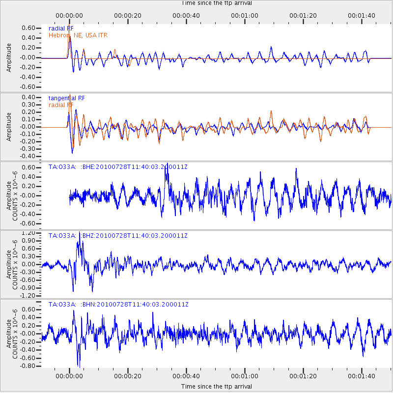
O33A Hebron, NE, USA - Earthquake Result Viewer
*The percent match for this event was below the threshold and hence no stack was calculated.
| Earthquake location: |
Fox Islands, Aleutian Islands |
| Earthquake latitude/longitude: |
52.7/-169.4 |
| Earthquake time(UTC): |
2010/07/28 (209) 11:31:46 GMT |
| Earthquake Depth: |
10 km |
| Earthquake Magnitude: |
5.6 MW, 5.2 MS, 5.2 MB, 5.1 ML |
| Earthquake Catalog/Contributor: |
WHDF/NEIC |
|
| Network: |
TA USArray Transportable Network (new EarthScope stations) |
| Station: |
O33A Hebron, NE, USA |
| Lat/Lon: |
40.08 N/97.58 W |
| Elevation: |
480 m |
|
| Distance: |
49.1 deg |
| Az: |
74.609 deg |
| Baz: |
310.072 deg |
| Ray Param: |
$rayparam |
*The percent match for this event was below the threshold and hence was not used in the summary stack. |
|
| Radial Match: |
47.74424 % |
| Radial Bump: |
400 |
| Transverse Match: |
66.471954 % |
| Transverse Bump: |
400 |
| SOD ConfigId: |
319893 |
| Insert Time: |
2011-01-05 13:54:48.580 +0000 |
| GWidth: |
2.5 |
| Max Bumps: |
400 |
| Tol: |
0.001 |
|
Signal To Noise
| Channel | StoN | STA | LTA |
| TA:O33A: :BHZ:20100728T11:40:03.200011Z | 6.7659545 | 5.3832224E-7 | 7.9563385E-8 |
| TA:O33A: :BHN:20100728T11:40:03.200011Z | 3.1050348 | 3.0012225E-7 | 9.665665E-8 |
| TA:O33A: :BHE:20100728T11:40:03.200011Z | 2.781172 | 2.7960294E-7 | 1.0053421E-7 |
| Arrivals |
| Ps | |
| PpPs | |
| PsPs/PpSs | |


