You are here: Home > Network List > UW - Pacific Northwest Regional Seismic Network Stations List
> Station RVSD Chattaroy, WA, USA > Earthquake Result Viewer
RVSD Chattaroy, WA, USA - Earthquake Result Viewer
| Earthquake location: |
Andreanof Islands, Aleutian Is. |
| Earthquake latitude/longitude: |
52.4/-176.9 |
| Earthquake time(UTC): |
2023/10/16 (289) 11:35:31 GMT |
| Earthquake Depth: |
187 km |
| Earthquake Magnitude: |
6.4 Mww |
| Earthquake Catalog/Contributor: |
NEIC PDE/us |
|
| Network: |
UW Pacific Northwest Regional Seismic Network |
| Station: |
RVSD Chattaroy, WA, USA |
| Lat/Lon: |
47.96 N/117.36 W |
| Elevation: |
611 m |
|
| Distance: |
37.4 deg |
| Az: |
72.419 deg |
| Baz: |
299.746 deg |
| Ray Param: |
0.07548003 |
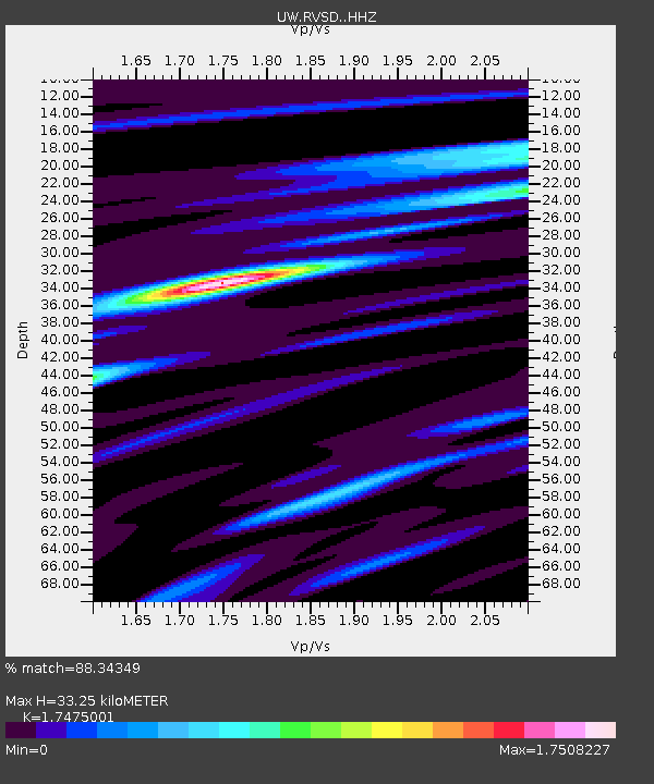
| Estimated Moho Depth: |
33.25 km |
| Estimated Crust Vp/Vs: |
1.75 |
| Assumed Crust Vp: |
6.571 km/s |
| Estimated Crust Vs: |
3.76 km/s |
| Estimated Crust Poisson's Ratio: |
0.26 |
|
| Radial Match: |
88.34349 % |
| Radial Bump: |
292 |
| Transverse Match: |
71.127525 % |
| Transverse Bump: |
400 |
| SOD ConfigId: |
31937991 |
| Insert Time: |
2023-10-30 12:44:33.885 +0000 |
| GWidth: |
2.5 |
| Max Bumps: |
400 |
| Tol: |
0.001 |
|

Signal To Noise
| Channel | StoN | STA | LTA |
| UW:RVSD: :HHZ:20231016T11:41:56.110003Z | 14.371503 | 5.420646E-6 | 3.7718016E-7 |
| UW:RVSD: :HHN:20231016T11:41:56.110003Z | 5.230325 | 1.472493E-6 | 2.815299E-7 |
| UW:RVSD: :HHE:20231016T11:41:56.110003Z | 13.190738 | 2.9965447E-6 | 2.2717036E-7 |
| Arrivals |
| Ps | 4.1 SECOND |
| PpPs | 13 SECOND |
| PsPs/PpSs | 17 SECOND |


