You are here: Home > Network List > UW - Pacific Northwest Regional Seismic Network Stations List
> Station SAW St. Andrews, WA, USA > Earthquake Result Viewer
SAW St. Andrews, WA, USA - Earthquake Result Viewer
| Earthquake location: |
Andreanof Islands, Aleutian Is. |
| Earthquake latitude/longitude: |
52.4/-176.9 |
| Earthquake time(UTC): |
2023/10/16 (289) 11:35:31 GMT |
| Earthquake Depth: |
187 km |
| Earthquake Magnitude: |
6.4 Mww |
| Earthquake Catalog/Contributor: |
NEIC PDE/us |
|
| Network: |
UW Pacific Northwest Regional Seismic Network |
| Station: |
SAW St. Andrews, WA, USA |
| Lat/Lon: |
47.70 N/119.40 W |
| Elevation: |
701 m |
|
| Distance: |
36.3 deg |
| Az: |
73.935 deg |
| Baz: |
299.448 deg |
| Ray Param: |
0.0760613 |
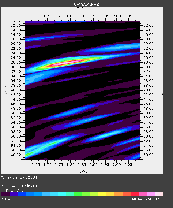
| Estimated Moho Depth: |
28.0 km |
| Estimated Crust Vp/Vs: |
1.78 |
| Assumed Crust Vp: |
6.419 km/s |
| Estimated Crust Vs: |
3.611 km/s |
| Estimated Crust Poisson's Ratio: |
0.27 |
|
| Radial Match: |
87.12184 % |
| Radial Bump: |
357 |
| Transverse Match: |
69.80274 % |
| Transverse Bump: |
400 |
| SOD ConfigId: |
31937991 |
| Insert Time: |
2023-10-30 12:44:36.999 +0000 |
| GWidth: |
2.5 |
| Max Bumps: |
400 |
| Tol: |
0.001 |
|

Signal To Noise
| Channel | StoN | STA | LTA |
| UW:SAW: :HHZ:20231016T11:41:47.120012Z | 18.054302 | 6.3809734E-6 | 3.5343226E-7 |
| UW:SAW: :HHN:20231016T11:41:47.120012Z | 7.144301 | 1.9763647E-6 | 2.7663515E-7 |
| UW:SAW: :HHE:20231016T11:41:47.120012Z | 10.161907 | 3.6506324E-6 | 3.592468E-7 |
| Arrivals |
| Ps | 3.6 SECOND |
| PpPs | 11 SECOND |
| PsPs/PpSs | 15 SECOND |


