You are here: Home > Network List > TA - USArray Transportable Network (new EarthScope stations) Stations List
> Station V38A Canehill, AR, USA > Earthquake Result Viewer
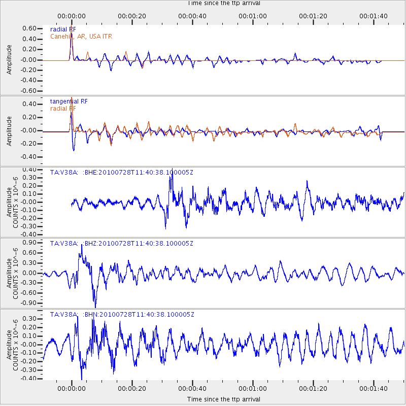
V38A Canehill, AR, USA - Earthquake Result Viewer
*The percent match for this event was below the threshold and hence no stack was calculated.
| Earthquake location: |
Fox Islands, Aleutian Islands |
| Earthquake latitude/longitude: |
52.7/-169.4 |
| Earthquake time(UTC): |
2010/07/28 (209) 11:31:46 GMT |
| Earthquake Depth: |
10 km |
| Earthquake Magnitude: |
5.6 MW, 5.2 MS, 5.2 MB, 5.1 ML |
| Earthquake Catalog/Contributor: |
WHDF/NEIC |
|
| Network: |
TA USArray Transportable Network (new EarthScope stations) |
| Station: |
V38A Canehill, AR, USA |
| Lat/Lon: |
35.86 N/94.41 W |
| Elevation: |
372 m |
|
| Distance: |
53.8 deg |
| Az: |
76.493 deg |
| Baz: |
313.195 deg |
| Ray Param: |
$rayparam |
*The percent match for this event was below the threshold and hence was not used in the summary stack. |
|
| Radial Match: |
73.26628 % |
| Radial Bump: |
327 |
| Transverse Match: |
72.41894 % |
| Transverse Bump: |
400 |
| SOD ConfigId: |
319893 |
| Insert Time: |
2011-01-05 13:56:00.518 +0000 |
| GWidth: |
2.5 |
| Max Bumps: |
400 |
| Tol: |
0.001 |
|
Signal To Noise
| Channel | StoN | STA | LTA |
| TA:V38A: :BHZ:20100728T11:40:38.100005Z | 6.2838087 | 3.8623716E-7 | 6.146546E-8 |
| TA:V38A: :BHN:20100728T11:40:38.100005Z | 1.8189908 | 1.9107979E-7 | 1.0504714E-7 |
| TA:V38A: :BHE:20100728T11:40:38.100005Z | 4.7054896 | 1.6151569E-7 | 3.4324948E-8 |
| Arrivals |
| Ps | |
| PpPs | |
| PsPs/PpSs | |


