You are here: Home > Network List > WU - The Southern Ontario Seismic Network Stations List
> Station TOBO Tobermory, Bruce Peninsula National Park, Ontario, Canada > Earthquake Result Viewer
TOBO Tobermory, Bruce Peninsula National Park, Ontario, Canada - Earthquake Result Viewer
| Earthquake location: |
Andreanof Islands, Aleutian Is. |
| Earthquake latitude/longitude: |
52.4/-176.9 |
| Earthquake time(UTC): |
2023/10/16 (289) 11:35:31 GMT |
| Earthquake Depth: |
187 km |
| Earthquake Magnitude: |
6.4 Mww |
| Earthquake Catalog/Contributor: |
NEIC PDE/us |
|
| Network: |
WU The Southern Ontario Seismic Network |
| Station: |
TOBO Tobermory, Bruce Peninsula National Park, Ontario, Canada |
| Lat/Lon: |
45.23 N/81.52 W |
| Elevation: |
169 m |
|
| Distance: |
58.7 deg |
| Az: |
55.425 deg |
| Baz: |
314.506 deg |
| Ray Param: |
0.06205851 |
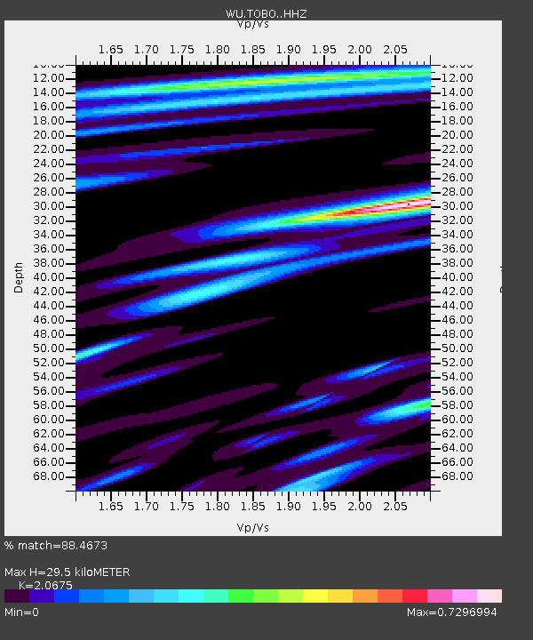
| Estimated Moho Depth: |
29.5 km |
| Estimated Crust Vp/Vs: |
2.07 |
| Assumed Crust Vp: |
6.53 km/s |
| Estimated Crust Vs: |
3.159 km/s |
| Estimated Crust Poisson's Ratio: |
0.35 |
|
| Radial Match: |
88.4673 % |
| Radial Bump: |
289 |
| Transverse Match: |
53.857723 % |
| Transverse Bump: |
400 |
| SOD ConfigId: |
31937991 |
| Insert Time: |
2023-10-30 12:46:45.076 +0000 |
| GWidth: |
2.5 |
| Max Bumps: |
400 |
| Tol: |
0.001 |
|

Signal To Noise
| Channel | StoN | STA | LTA |
| WU:TOBO: :HHZ:20231016T11:44:38.934984Z | 9.985339 | 2.8909988E-6 | 2.895243E-7 |
| WU:TOBO: :HHN:20231016T11:44:38.934984Z | 5.3615456 | 1.0975072E-6 | 2.0469976E-7 |
| WU:TOBO: :HHE:20231016T11:44:38.934984Z | 4.2743044 | 1.0192215E-6 | 2.384532E-7 |
| Arrivals |
| Ps | 5.0 SECOND |
| PpPs | 13 SECOND |
| PsPs/PpSs | 18 SECOND |


