You are here: Home > Network List > WW - Idaho Seismic Network () Stations List
> Station BILL Emerald Creek, Idaho > Earthquake Result Viewer
BILL Emerald Creek, Idaho - Earthquake Result Viewer
| Earthquake location: |
Andreanof Islands, Aleutian Is. |
| Earthquake latitude/longitude: |
52.4/-176.9 |
| Earthquake time(UTC): |
2023/10/16 (289) 11:35:31 GMT |
| Earthquake Depth: |
187 km |
| Earthquake Magnitude: |
6.4 Mww |
| Earthquake Catalog/Contributor: |
NEIC PDE/us |
|
| Network: |
WW Idaho Seismic Network () |
| Station: |
BILL Emerald Creek, Idaho |
| Lat/Lon: |
47.03 N/116.34 W |
| Elevation: |
866 m |
|
| Distance: |
38.5 deg |
| Az: |
73.158 deg |
| Baz: |
301.078 deg |
| Ray Param: |
0.0748447 |
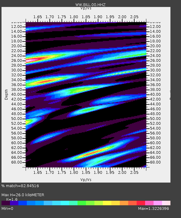
| Estimated Moho Depth: |
26.0 km |
| Estimated Crust Vp/Vs: |
1.60 |
| Assumed Crust Vp: |
6.571 km/s |
| Estimated Crust Vs: |
4.107 km/s |
| Estimated Crust Poisson's Ratio: |
0.18 |
|
| Radial Match: |
82.94516 % |
| Radial Bump: |
396 |
| Transverse Match: |
69.96923 % |
| Transverse Bump: |
400 |
| SOD ConfigId: |
31937991 |
| Insert Time: |
2023-10-30 12:46:51.781 +0000 |
| GWidth: |
2.5 |
| Max Bumps: |
400 |
| Tol: |
0.001 |
|

Signal To Noise
| Channel | StoN | STA | LTA |
| WW:BILL:00:HHZ:20231016T11:42:05.029986Z | 12.723824 | 4.218566E-6 | 3.3154862E-7 |
| WW:BILL:00:HHN:20231016T11:42:05.029986Z | 5.7068973 | 1.6560492E-6 | 2.901838E-7 |
| WW:BILL:00:HHE:20231016T11:42:05.029986Z | 7.9240246 | 2.162174E-6 | 2.728631E-7 |
| Arrivals |
| Ps | 2.6 SECOND |
| PpPs | 9.5 SECOND |
| PsPs/PpSs | 12 SECOND |


