You are here: Home > Network List > WW - Idaho Seismic Network () Stations List
> Station TYLR Tyler Ranch Idaho > Earthquake Result Viewer
TYLR Tyler Ranch Idaho - Earthquake Result Viewer
| Earthquake location: |
Andreanof Islands, Aleutian Is. |
| Earthquake latitude/longitude: |
52.4/-176.9 |
| Earthquake time(UTC): |
2023/10/16 (289) 11:35:31 GMT |
| Earthquake Depth: |
187 km |
| Earthquake Magnitude: |
6.4 Mww |
| Earthquake Catalog/Contributor: |
NEIC PDE/us |
|
| Network: |
WW Idaho Seismic Network () |
| Station: |
TYLR Tyler Ranch Idaho |
| Lat/Lon: |
45.10 N/114.85 W |
| Elevation: |
1203 m |
|
| Distance: |
40.4 deg |
| Az: |
74.859 deg |
| Baz: |
303.459 deg |
| Ray Param: |
0.073717386 |
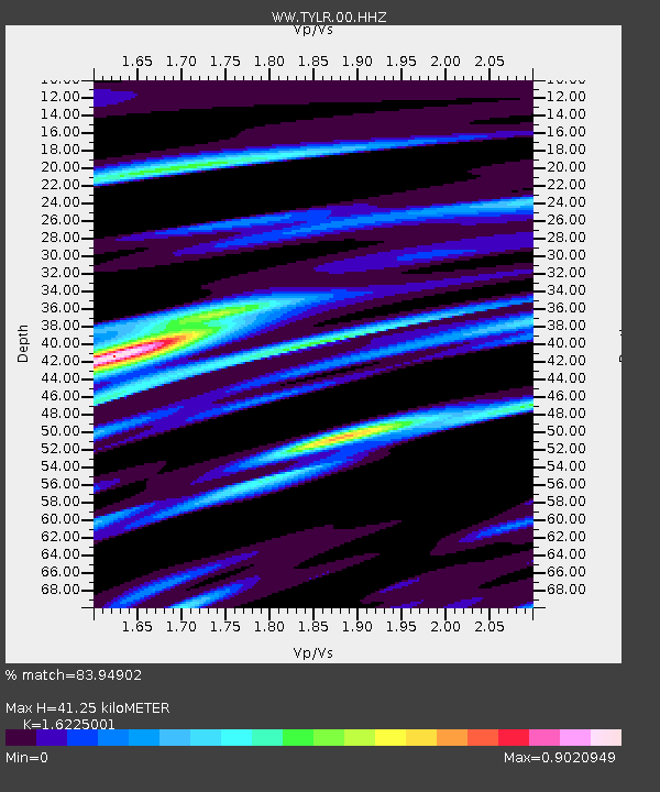
| Estimated Moho Depth: |
41.25 km |
| Estimated Crust Vp/Vs: |
1.62 |
| Assumed Crust Vp: |
6.577 km/s |
| Estimated Crust Vs: |
4.054 km/s |
| Estimated Crust Poisson's Ratio: |
0.19 |
|
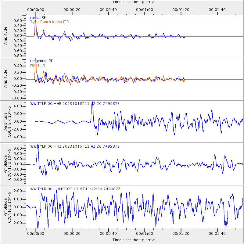
| Radial Match: |
83.94902 % |
| Radial Bump: |
400 |
| Transverse Match: |
79.07027 % |
| Transverse Bump: |
400 |
| SOD ConfigId: |
31937991 |
| Insert Time: |
2023-10-30 12:46:54.332 +0000 |
| GWidth: |
2.5 |
| Max Bumps: |
400 |
| Tol: |
0.001 |
|
Signal To Noise
| Channel | StoN | STA | LTA |
| WW:TYLR:00:HHZ:20231016T11:42:20.749987Z | 34.18589 | 4.7517983E-6 | 1.3899883E-7 |
| WW:TYLR:00:HHN:20231016T11:42:20.749987Z | 8.793173 | 1.2891506E-6 | 1.4660813E-7 |
| WW:TYLR:00:HHE:20231016T11:42:20.749987Z | 11.0989065 | 2.2198908E-6 | 2.0000986E-7 |
| Arrivals |
| Ps | 4.2 SECOND |
| PpPs | 15 SECOND |
| PsPs/PpSs | 19 SECOND |


