You are here: Home > Network List > US - United States National Seismic Network Stations List
> Station CBKS Cedar Bluff, Kansas, USA > Earthquake Result Viewer
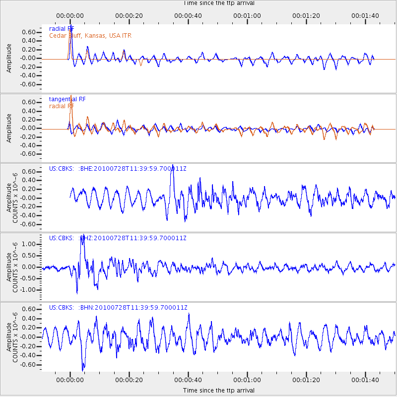
CBKS Cedar Bluff, Kansas, USA - Earthquake Result Viewer
*The percent match for this event was below the threshold and hence no stack was calculated.
| Earthquake location: |
Fox Islands, Aleutian Islands |
| Earthquake latitude/longitude: |
52.7/-169.4 |
| Earthquake time(UTC): |
2010/07/28 (209) 11:31:46 GMT |
| Earthquake Depth: |
10 km |
| Earthquake Magnitude: |
5.6 MW, 5.2 MS, 5.2 MB, 5.1 ML |
| Earthquake Catalog/Contributor: |
WHDF/NEIC |
|
| Network: |
US United States National Seismic Network |
| Station: |
CBKS Cedar Bluff, Kansas, USA |
| Lat/Lon: |
38.81 N/99.74 W |
| Elevation: |
677 m |
|
| Distance: |
48.7 deg |
| Az: |
77.314 deg |
| Baz: |
310.489 deg |
| Ray Param: |
$rayparam |
*The percent match for this event was below the threshold and hence was not used in the summary stack. |
|
| Radial Match: |
68.46713 % |
| Radial Bump: |
400 |
| Transverse Match: |
60.81115 % |
| Transverse Bump: |
400 |
| SOD ConfigId: |
319893 |
| Insert Time: |
2011-01-05 13:57:55.482 +0000 |
| GWidth: |
2.5 |
| Max Bumps: |
400 |
| Tol: |
0.001 |
|
Signal To Noise
| Channel | StoN | STA | LTA |
| US:CBKS: :BHZ:20100728T11:39:59.700011Z | 9.456731 | 6.597487E-7 | 6.976499E-8 |
| US:CBKS: :BHN:20100728T11:39:59.700011Z | 2.060815 | 2.8333355E-7 | 1.3748615E-7 |
| US:CBKS: :BHE:20100728T11:39:59.700011Z | 1.9603347 | 3.0229583E-7 | 1.5420623E-7 |
| Arrivals |
| Ps | |
| PpPs | |
| PsPs/PpSs | |


