You are here: Home > Network List > AK - Alaska Regional Network Stations List
> Station BRLK Bradley Lake > Earthquake Result Viewer
BRLK Bradley Lake - Earthquake Result Viewer
| Earthquake location: |
Mindanao, Philippines |
| Earthquake latitude/longitude: |
6.5/123.2 |
| Earthquake time(UTC): |
2010/07/29 (210) 07:31:56 GMT |
| Earthquake Depth: |
627 km |
| Earthquake Magnitude: |
6.1 MB, 6.6 MW, 6.6 MW |
| Earthquake Catalog/Contributor: |
WHDF/NEIC |
|
| Network: |
AK Alaska Regional Network |
| Station: |
BRLK Bradley Lake |
| Lat/Lon: |
59.75 N/150.91 W |
| Elevation: |
409 m |
|
| Distance: |
82.3 deg |
| Az: |
30.633 deg |
| Baz: |
269.718 deg |
| Ray Param: |
0.04505806 |
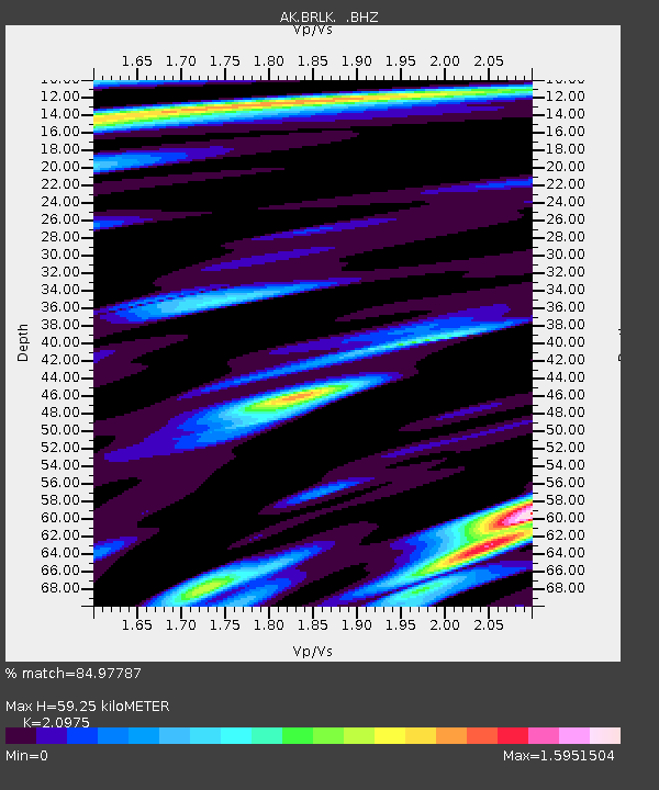
| Estimated Moho Depth: |
59.25 km |
| Estimated Crust Vp/Vs: |
2.10 |
| Assumed Crust Vp: |
6.24 km/s |
| Estimated Crust Vs: |
2.975 km/s |
| Estimated Crust Poisson's Ratio: |
0.35 |
|
| Radial Match: |
84.97787 % |
| Radial Bump: |
400 |
| Transverse Match: |
87.974014 % |
| Transverse Bump: |
400 |
| SOD ConfigId: |
319893 |
| Insert Time: |
2011-01-05 14:02:31.048 +0000 |
| GWidth: |
2.5 |
| Max Bumps: |
400 |
| Tol: |
0.001 |
|

Signal To Noise
| Channel | StoN | STA | LTA |
| AK:BRLK: :BHZ:20100729T07:42:43.24802Z | 38.36147 | 1.7924071E-6 | 4.6724153E-8 |
| AK:BRLK: :BHN:20100729T07:42:43.24802Z | 3.2445714 | 1.738537E-7 | 5.3582948E-8 |
| AK:BRLK: :BHE:20100729T07:42:43.24802Z | 10.910716 | 6.286669E-7 | 5.7619218E-8 |
| Arrivals |
| Ps | 11 SECOND |
| PpPs | 29 SECOND |
| PsPs/PpSs | 39 SECOND |


