You are here: Home > Network List > AU - Australian Seismological Centre Stations List
> Station ARMA Armidale, New South Wales > Earthquake Result Viewer
ARMA Armidale, New South Wales - Earthquake Result Viewer
| Earthquake location: |
Mindanao, Philippines |
| Earthquake latitude/longitude: |
6.5/123.2 |
| Earthquake time(UTC): |
2010/07/29 (210) 07:31:56 GMT |
| Earthquake Depth: |
627 km |
| Earthquake Magnitude: |
6.1 MB, 6.6 MW, 6.6 MW |
| Earthquake Catalog/Contributor: |
WHDF/NEIC |
|
| Network: |
AU Australian Seismological Centre |
| Station: |
ARMA Armidale, New South Wales |
| Lat/Lon: |
30.42 S/151.63 E |
| Elevation: |
1112 m |
|
| Distance: |
45.7 deg |
| Az: |
144.998 deg |
| Baz: |
318.717 deg |
| Ray Param: |
0.06793505 |
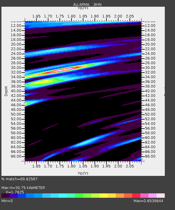
| Estimated Moho Depth: |
30.75 km |
| Estimated Crust Vp/Vs: |
1.76 |
| Assumed Crust Vp: |
6.577 km/s |
| Estimated Crust Vs: |
3.731 km/s |
| Estimated Crust Poisson's Ratio: |
0.26 |
|
| Radial Match: |
88.62597 % |
| Radial Bump: |
400 |
| Transverse Match: |
71.83068 % |
| Transverse Bump: |
400 |
| SOD ConfigId: |
319893 |
| Insert Time: |
2011-01-05 14:03:59.967 +0000 |
| GWidth: |
2.5 |
| Max Bumps: |
400 |
| Tol: |
0.001 |
|

Signal To Noise
| Channel | StoN | STA | LTA |
| AU:ARMA: :BHZ:20100729T07:38:53.244999Z | 11.887609 | 5.5552478E-6 | 4.6731418E-7 |
| AU:ARMA: :BHN:20100729T07:38:53.244999Z | 8.589731 | 2.5907236E-6 | 3.0160706E-7 |
| AU:ARMA: :BHE:20100729T07:38:53.244999Z | 4.6121893 | 1.9316558E-6 | 4.1881538E-7 |
| Arrivals |
| Ps | 3.8 SECOND |
| PpPs | 12 SECOND |
| PsPs/PpSs | 16 SECOND |


