You are here: Home > Network List > G - GEOSCOPE Stations List
> Station KIP Kipapa - Hawaii, USA > Earthquake Result Viewer
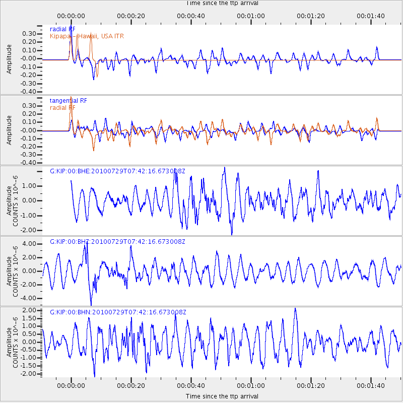
KIP Kipapa - Hawaii, USA - Earthquake Result Viewer
*The percent match for this event was below the threshold and hence no stack was calculated.
| Earthquake location: |
Mindanao, Philippines |
| Earthquake latitude/longitude: |
6.5/123.2 |
| Earthquake time(UTC): |
2010/07/29 (210) 07:31:56 GMT |
| Earthquake Depth: |
627 km |
| Earthquake Magnitude: |
6.1 MB, 6.6 MW, 6.6 MW |
| Earthquake Catalog/Contributor: |
WHDF/NEIC |
|
| Network: |
G GEOSCOPE |
| Station: |
KIP Kipapa - Hawaii, USA |
| Lat/Lon: |
21.42 N/158.01 W |
| Elevation: |
70 m |
|
| Distance: |
77.2 deg |
| Az: |
69.577 deg |
| Baz: |
272.043 deg |
| Ray Param: |
$rayparam |
*The percent match for this event was below the threshold and hence was not used in the summary stack. |
|
| Radial Match: |
65.44863 % |
| Radial Bump: |
400 |
| Transverse Match: |
55.492268 % |
| Transverse Bump: |
400 |
| SOD ConfigId: |
319893 |
| Insert Time: |
2011-01-05 14:05:15.210 +0000 |
| GWidth: |
2.5 |
| Max Bumps: |
400 |
| Tol: |
0.001 |
|
Signal To Noise
| Channel | StoN | STA | LTA |
| G:KIP:00:BHZ:20100729T07:42:16.673008Z | 2.2253726 | 1.6928369E-6 | 7.606982E-7 |
| G:KIP:00:BHN:20100729T07:42:16.673008Z | 1.9120766 | 7.127349E-7 | 3.7275436E-7 |
| G:KIP:00:BHE:20100729T07:42:16.673008Z | 1.493344 | 8.903982E-7 | 5.9624455E-7 |
| Arrivals |
| Ps | |
| PpPs | |
| PsPs/PpSs | |


