You are here: Home > Network List > IU - Global Seismograph Network (GSN - IRIS/USGS) Stations List
> Station CTAO Charters Towers, Australia > Earthquake Result Viewer
CTAO Charters Towers, Australia - Earthquake Result Viewer
| Earthquake location: |
Mindanao, Philippines |
| Earthquake latitude/longitude: |
6.5/123.2 |
| Earthquake time(UTC): |
2010/07/29 (210) 07:31:56 GMT |
| Earthquake Depth: |
627 km |
| Earthquake Magnitude: |
6.1 MB, 6.6 MW, 6.6 MW |
| Earthquake Catalog/Contributor: |
WHDF/NEIC |
|
| Network: |
IU Global Seismograph Network (GSN - IRIS/USGS) |
| Station: |
CTAO Charters Towers, Australia |
| Lat/Lon: |
20.09 S/146.25 E |
| Elevation: |
357 m |
|
| Distance: |
34.8 deg |
| Az: |
139.945 deg |
| Baz: |
317.134 deg |
| Ray Param: |
0.07427374 |
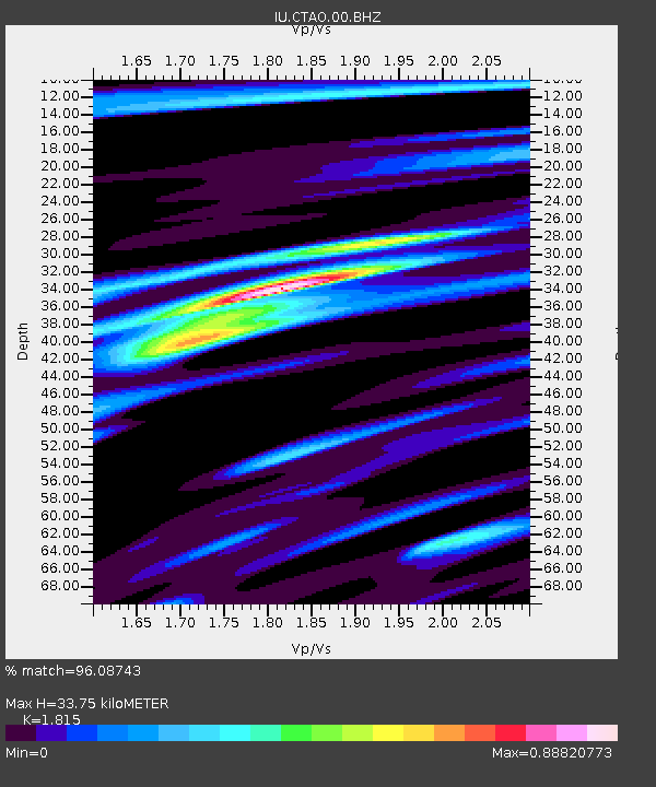
| Estimated Moho Depth: |
33.75 km |
| Estimated Crust Vp/Vs: |
1.82 |
| Assumed Crust Vp: |
6.522 km/s |
| Estimated Crust Vs: |
3.593 km/s |
| Estimated Crust Poisson's Ratio: |
0.28 |
|
| Radial Match: |
96.08743 % |
| Radial Bump: |
333 |
| Transverse Match: |
82.010956 % |
| Transverse Bump: |
400 |
| SOD ConfigId: |
319893 |
| Insert Time: |
2011-01-05 14:06:21.075 +0000 |
| GWidth: |
2.5 |
| Max Bumps: |
400 |
| Tol: |
0.001 |
|
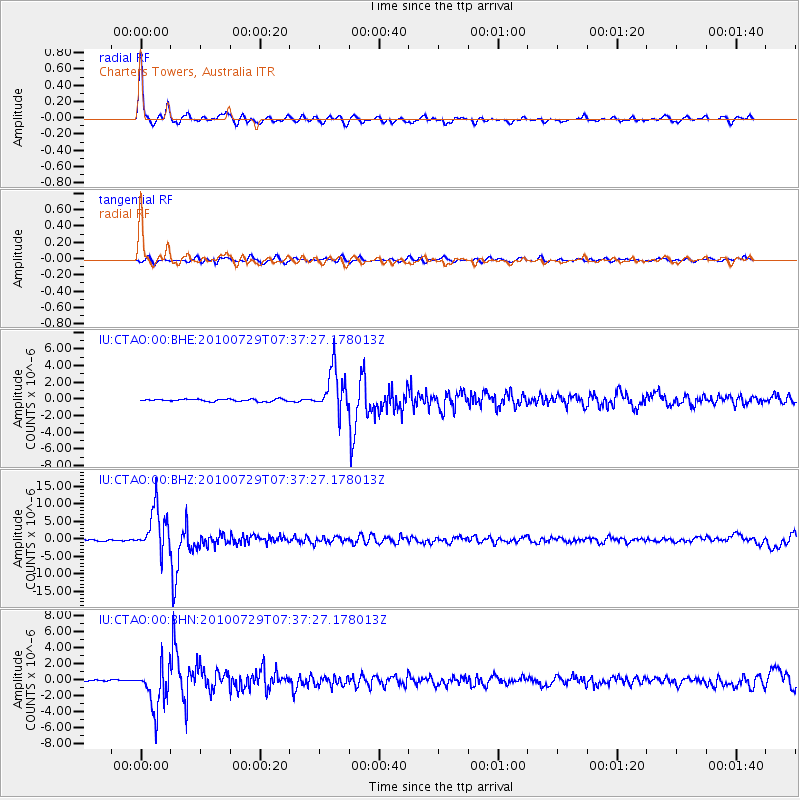
Signal To Noise
| Channel | StoN | STA | LTA |
| IU:CTAO:00:BHZ:20100729T07:37:27.178013Z | 29.830564 | 6.278978E-6 | 2.1048807E-7 |
| IU:CTAO:00:BHN:20100729T07:37:27.178013Z | 21.91131 | 2.7916476E-6 | 1.274067E-7 |
| IU:CTAO:00:BHE:20100729T07:37:27.178013Z | 19.47924 | 2.618253E-6 | 1.3441247E-7 |
| Arrivals |
| Ps | 4.5 SECOND |
| PpPs | 14 SECOND |
| PsPs/PpSs | 18 SECOND |


