You are here: Home > Network List > GT - Global Telemetered Seismograph Network (USAF/USGS) Stations List
> Station PLCA Paso Flores, Argentina > Earthquake Result Viewer
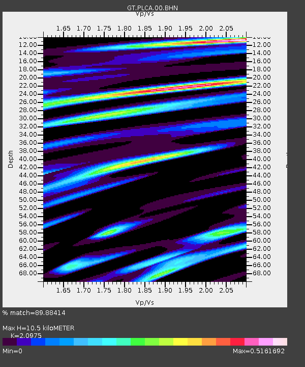
PLCA Paso Flores, Argentina - Earthquake Result Viewer
| Earthquake location: |
Near Coast Of Chiapas, Mexico |
| Earthquake latitude/longitude: |
14.8/-92.3 |
| Earthquake time(UTC): |
2019/02/01 (032) 16:14:13 GMT |
| Earthquake Depth: |
68 km |
| Earthquake Magnitude: |
6.6 Mww |
| Earthquake Catalog/Contributor: |
NEIC PDE/us |
|
| Network: |
GT Global Telemetered Seismograph Network (USAF/USGS) |
| Station: |
PLCA Paso Flores, Argentina |
| Lat/Lon: |
40.73 S/70.55 W |
| Elevation: |
1050 m |
|
| Distance: |
58.8 deg |
| Az: |
160.779 deg |
| Baz: |
335.222 deg |
| Ray Param: |
0.062440623 |
| Estimated Moho Depth: |
10.5 km |
| Estimated Crust Vp/Vs: |
2.10 |
| Assumed Crust Vp: |
6.597 km/s |
| Estimated Crust Vs: |
3.145 km/s |
| Estimated Crust Poisson's Ratio: |
0.35 |
|
| Radial Match: |
89.88414 % |
| Radial Bump: |
358 |
| Transverse Match: |
70.770096 % |
| Transverse Bump: |
400 |
| SOD ConfigId: |
3287751 |
| Insert Time: |
2019-02-15 16:29:04.935 +0000 |
| GWidth: |
2.5 |
| Max Bumps: |
400 |
| Tol: |
0.001 |
|

Signal To Noise
| Channel | StoN | STA | LTA |
| GT:PLCA:00:BHZ:20190201T16:23:33.574985Z | 19.767948 | 2.823385E-6 | 1.4282642E-7 |
| GT:PLCA:00:BHN:20190201T16:23:33.574985Z | 6.6094913 | 1.1079154E-6 | 1.676249E-7 |
| GT:PLCA:00:BHE:20190201T16:23:33.574985Z | 2.3969204 | 5.718864E-7 | 2.3859215E-7 |
| Arrivals |
| Ps | 1.8 SECOND |
| PpPs | 4.7 SECOND |
| PsPs/PpSs | 6.5 SECOND |


