You are here: Home > Network List > CI - Caltech Regional Seismic Network Stations List
> Station PLM Palomar, Palomar Mountain, CA, USA > Earthquake Result Viewer
PLM Palomar, Palomar Mountain, CA, USA - Earthquake Result Viewer
| Earthquake location: |
Off East Coast Of Kamchatka |
| Earthquake latitude/longitude: |
52.5/159.8 |
| Earthquake time(UTC): |
2010/07/30 (211) 03:56:13 GMT |
| Earthquake Depth: |
23 km |
| Earthquake Magnitude: |
6.1 MB, 6.3 MS, 6.3 MW, 6.3 MW |
| Earthquake Catalog/Contributor: |
WHDF/NEIC |
|
| Network: |
CI Caltech Regional Seismic Network |
| Station: |
PLM Palomar, Palomar Mountain, CA, USA |
| Lat/Lon: |
33.35 N/116.86 W |
| Elevation: |
1691 m |
|
| Distance: |
60.5 deg |
| Az: |
72.807 deg |
| Baz: |
315.75 deg |
| Ray Param: |
0.06147724 |
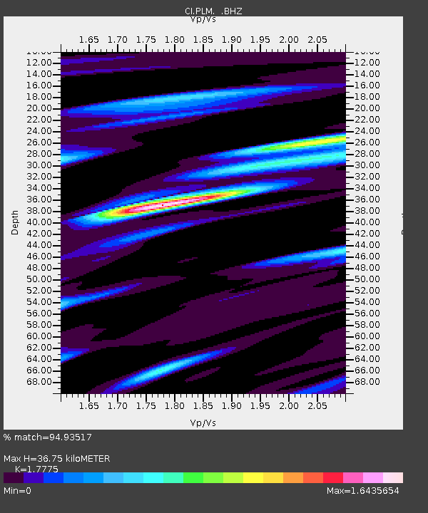
| Estimated Moho Depth: |
36.75 km |
| Estimated Crust Vp/Vs: |
1.78 |
| Assumed Crust Vp: |
6.264 km/s |
| Estimated Crust Vs: |
3.524 km/s |
| Estimated Crust Poisson's Ratio: |
0.27 |
|
| Radial Match: |
94.93517 % |
| Radial Bump: |
400 |
| Transverse Match: |
92.54317 % |
| Transverse Bump: |
400 |
| SOD ConfigId: |
319893 |
| Insert Time: |
2011-01-05 14:14:26.304 +0000 |
| GWidth: |
2.5 |
| Max Bumps: |
400 |
| Tol: |
0.001 |
|

Signal To Noise
| Channel | StoN | STA | LTA |
| CI:PLM: :BHZ:20100730T04:05:50.619973Z | 14.60153 | 1.3767946E-6 | 9.429112E-8 |
| CI:PLM: :BHN:20100730T04:05:50.619973Z | 9.908745 | 6.646588E-7 | 6.7078E-8 |
| CI:PLM: :BHE:20100730T04:05:50.619973Z | 5.3699346 | 5.4112013E-7 | 1.0076848E-7 |
| Arrivals |
| Ps | 4.8 SECOND |
| PpPs | 16 SECOND |
| PsPs/PpSs | 20 SECOND |


