You are here: Home > Network List > CI - Caltech Regional Seismic Network Stations List
> Station RPV Rancho Palos Verdes, California, USA > Earthquake Result Viewer
RPV Rancho Palos Verdes, California, USA - Earthquake Result Viewer
| Earthquake location: |
Off East Coast Of Kamchatka |
| Earthquake latitude/longitude: |
52.5/159.8 |
| Earthquake time(UTC): |
2010/07/30 (211) 03:56:13 GMT |
| Earthquake Depth: |
23 km |
| Earthquake Magnitude: |
6.1 MB, 6.3 MS, 6.3 MW, 6.3 MW |
| Earthquake Catalog/Contributor: |
WHDF/NEIC |
|
| Network: |
CI Caltech Regional Seismic Network |
| Station: |
RPV Rancho Palos Verdes, California, USA |
| Lat/Lon: |
33.74 N/118.40 W |
| Elevation: |
64 m |
|
| Distance: |
59.3 deg |
| Az: |
73.553 deg |
| Baz: |
315.277 deg |
| Ray Param: |
0.06225147 |
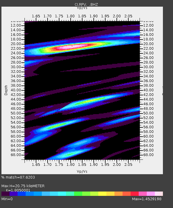
| Estimated Moho Depth: |
20.75 km |
| Estimated Crust Vp/Vs: |
1.81 |
| Assumed Crust Vp: |
6.048 km/s |
| Estimated Crust Vs: |
3.351 km/s |
| Estimated Crust Poisson's Ratio: |
0.28 |
|
| Radial Match: |
87.6203 % |
| Radial Bump: |
400 |
| Transverse Match: |
90.00662 % |
| Transverse Bump: |
395 |
| SOD ConfigId: |
319893 |
| Insert Time: |
2011-01-05 14:15:25.874 +0000 |
| GWidth: |
2.5 |
| Max Bumps: |
400 |
| Tol: |
0.001 |
|

Signal To Noise
| Channel | StoN | STA | LTA |
| CI:RPV: :BHZ:20100730T04:05:42.545022Z | 7.9563127 | 1.6673634E-6 | 2.0956485E-7 |
| CI:RPV: :BHN:20100730T04:05:42.545022Z | 1.9506129 | 6.035883E-7 | 3.0943522E-7 |
| CI:RPV: :BHE:20100730T04:05:42.545022Z | 2.9338522 | 7.746038E-7 | 2.640228E-7 |
| Arrivals |
| Ps | 2.9 SECOND |
| PpPs | 9.2 SECOND |
| PsPs/PpSs | 12 SECOND |


