You are here: Home > Network List > CI - Caltech Regional Seismic Network Stations List
> Station VCS Vincent Substation, Palmdale, CA, USA > Earthquake Result Viewer
VCS Vincent Substation, Palmdale, CA, USA - Earthquake Result Viewer
| Earthquake location: |
Off East Coast Of Kamchatka |
| Earthquake latitude/longitude: |
52.5/159.8 |
| Earthquake time(UTC): |
2010/07/30 (211) 03:56:13 GMT |
| Earthquake Depth: |
23 km |
| Earthquake Magnitude: |
6.1 MB, 6.3 MS, 6.3 MW, 6.3 MW |
| Earthquake Catalog/Contributor: |
WHDF/NEIC |
|
| Network: |
CI Caltech Regional Seismic Network |
| Station: |
VCS Vincent Substation, Palmdale, CA, USA |
| Lat/Lon: |
34.48 N/118.12 W |
| Elevation: |
991 m |
|
| Distance: |
58.9 deg |
| Az: |
72.75 deg |
| Baz: |
315.024 deg |
| Ray Param: |
0.062486548 |
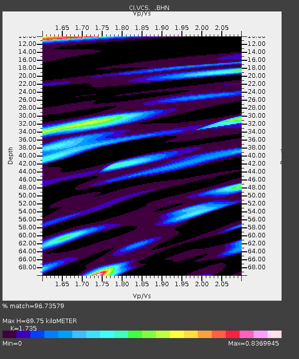
| Estimated Moho Depth: |
69.75 km |
| Estimated Crust Vp/Vs: |
1.74 |
| Assumed Crust Vp: |
6.1 km/s |
| Estimated Crust Vs: |
3.516 km/s |
| Estimated Crust Poisson's Ratio: |
0.25 |
|
| Radial Match: |
96.73579 % |
| Radial Bump: |
314 |
| Transverse Match: |
89.18239 % |
| Transverse Bump: |
400 |
| SOD ConfigId: |
319893 |
| Insert Time: |
2011-01-05 14:15:53.922 +0000 |
| GWidth: |
2.5 |
| Max Bumps: |
400 |
| Tol: |
0.001 |
|

Signal To Noise
| Channel | StoN | STA | LTA |
| CI:VCS: :BHZ:20100730T04:05:40.093972Z | 21.550144 | 1.874177E-6 | 8.696819E-8 |
| CI:VCS: :BHN:20100730T04:05:40.093972Z | 5.3129663 | 6.82349E-7 | 1.284309E-7 |
| CI:VCS: :BHE:20100730T04:05:40.093972Z | 5.2314425 | 6.6504475E-7 | 1.2712454E-7 |
| Arrivals |
| Ps | 8.8 SECOND |
| PpPs | 30 SECOND |
| PsPs/PpSs | 39 SECOND |


