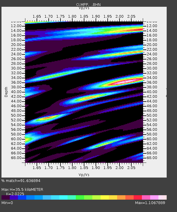
MPP McPhearson Peak - Earthquake Result Viewer
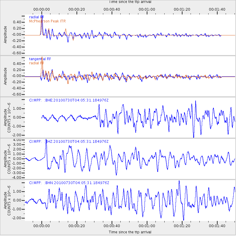
Earthquake location: Off East Coast Of Kamchatka
Earthquake latitude/longitude: 52.5/159.8
Earthquake time(UTC): 2010/07/30 (211) 03:56:13 GMT
Earthquake Depth: 23 km
Earthquake Magnitude: 6.1 MB, 6.3 MS, 6.3 MW, 6.3 MW
Earthquake Catalog/Contributor: WHDF/NEIC
Network: CI Caltech Regional Seismic Network
Station: MPP McPhearson Peak
Lat/Lon: 34.89 N/119.81 W
Elevation: 1739 m
Distance: 57.7 deg
Az: 73.57 deg
Baz: 314.494 deg
Ray Param: 0.06331677
Estimated Moho Depth: 35.5 km
Estimated Crust Vp/Vs: 2.02
Assumed Crust Vp: 6.1 km/s
Estimated Crust Vs: 3.016 km/s
Estimated Crust Poisson's Ratio: 0.34
Radial Match: 91.636894 %
Radial Bump: 400
Transverse Match: 89.2238 %
Transverse Bump: 400
SOD ConfigId: 319893
Insert Time: 2011-01-05 14:17:14.278 +0000
GWidth: 2.5
Max Bumps: 400
Tol: 0.001

Signal To Noise

ChannelStoNSTALTA
CI:MPP: :BHZ:20100730T04:05:31.184976Z14.5031761.688848E-61.1644677E-7
CI:MPP: :BHN:20100730T04:05:31.184976Z2.90905525.536169E-71.9030814E-7
CI:MPP: :BHE:20100730T04:05:31.184976Z3.10236555.61297E-71.8092547E-7
Arrivals
Ps6.2 SECOND
PpPs17 SECOND
PsPs/PpSs23 SECOND