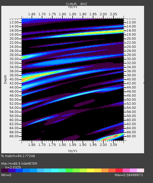
MUR Murrieta - Earthquake Result Viewer
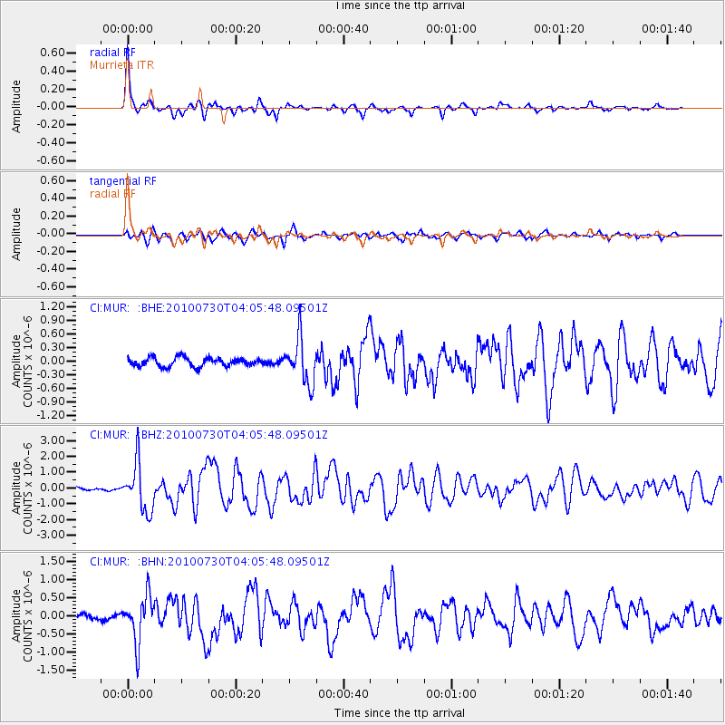
Earthquake location: Off East Coast Of Kamchatka
Earthquake latitude/longitude: 52.5/159.8
Earthquake time(UTC): 2010/07/30 (211) 03:56:13 GMT
Earthquake Depth: 23 km
Earthquake Magnitude: 6.1 MB, 6.3 MS, 6.3 MW, 6.3 MW
Earthquake Catalog/Contributor: WHDF/NEIC
Network: CI Caltech Regional Seismic Network
Station: MUR Murrieta
Lat/Lon: 33.60 N/117.20 W
Elevation: 562 m
Distance: 60.1 deg
Az: 72.838 deg
Baz: 315.583 deg
Ray Param: 0.06172128
Estimated Moho Depth: 68.5 km
Estimated Crust Vp/Vs: 2.03
Assumed Crust Vp: 6.264 km/s
Estimated Crust Vs: 3.082 km/s
Estimated Crust Poisson's Ratio: 0.34
Radial Match: 94.177246 %
Radial Bump: 308
Transverse Match: 87.35684 %
Transverse Bump: 400
SOD ConfigId: 319893
Insert Time: 2011-01-05 14:18:18.854 +0000
GWidth: 2.5
Max Bumps: 400
Tol: 0.001

Signal To Noise

ChannelStoNSTALTA
CI:MUR: :BHZ:20100730T04:05:48.09501Z24.1996521.5406754E-66.366519E-8
CI:MUR: :BHN:20100730T04:05:48.09501Z12.3274276.411683E-75.2011526E-8
CI:MUR: :BHE:20100730T04:05:48.09501Z5.22204974.980557E-79.5375526E-8
Arrivals
Ps12 SECOND
PpPs32 SECOND
PsPs/PpSs44 SECOND