You are here: Home > Network List > NE - New England Seismic Network Stations List
> Station HNH Hanover, NH, USA > Earthquake Result Viewer
HNH Hanover, NH, USA - Earthquake Result Viewer
| Earthquake location: |
Near Coast Of Chiapas, Mexico |
| Earthquake latitude/longitude: |
14.8/-92.3 |
| Earthquake time(UTC): |
2019/02/01 (032) 16:14:13 GMT |
| Earthquake Depth: |
68 km |
| Earthquake Magnitude: |
6.6 Mww |
| Earthquake Catalog/Contributor: |
NEIC PDE/us |
|
| Network: |
NE New England Seismic Network |
| Station: |
HNH Hanover, NH, USA |
| Lat/Lon: |
43.71 N/72.29 W |
| Elevation: |
180 m |
|
| Distance: |
33.5 deg |
| Az: |
26.696 deg |
| Baz: |
216.819 deg |
| Ray Param: |
0.07799376 |
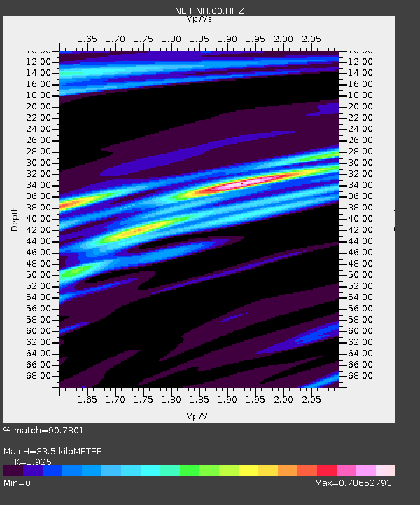
| Estimated Moho Depth: |
33.5 km |
| Estimated Crust Vp/Vs: |
1.92 |
| Assumed Crust Vp: |
6.419 km/s |
| Estimated Crust Vs: |
3.335 km/s |
| Estimated Crust Poisson's Ratio: |
0.32 |
|
| Radial Match: |
90.7801 % |
| Radial Bump: |
317 |
| Transverse Match: |
80.39801 % |
| Transverse Bump: |
400 |
| SOD ConfigId: |
3287751 |
| Insert Time: |
2019-02-15 16:30:30.692 +0000 |
| GWidth: |
2.5 |
| Max Bumps: |
400 |
| Tol: |
0.001 |
|

Signal To Noise
| Channel | StoN | STA | LTA |
| NE:HNH:00:HHZ:20190201T16:20:16.009006Z | 6.0831237 | 3.0460888E-6 | 5.0074414E-7 |
| NE:HNH:00:HH1:20190201T16:20:16.009006Z | 4.4258714 | 1.5189399E-6 | 3.431957E-7 |
| NE:HNH:00:HH2:20190201T16:20:16.009006Z | 1.1532873 | 4.860888E-7 | 4.2148108E-7 |
| Arrivals |
| Ps | 5.2 SECOND |
| PpPs | 14 SECOND |
| PsPs/PpSs | 19 SECOND |


