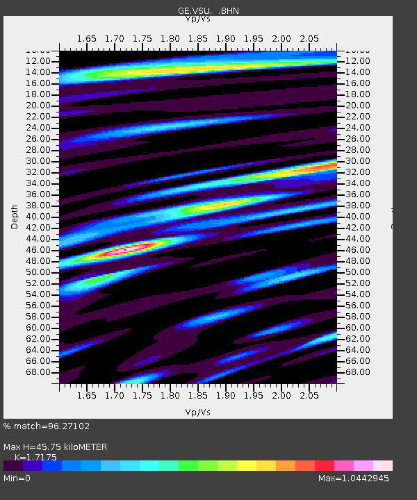
VSU GEOFON Station Vasula, Estonia - Earthquake Result Viewer

Earthquake location: Off East Coast Of Kamchatka
Earthquake latitude/longitude: 52.5/159.8
Earthquake time(UTC): 2010/07/30 (211) 03:56:13 GMT
Earthquake Depth: 23 km
Earthquake Magnitude: 6.1 MB, 6.3 MS, 6.3 MW, 6.3 MW
Earthquake Catalog/Contributor: WHDF/NEIC
Network: GE GEOFON
Station: VSU GEOFON Station Vasula, Estonia
Lat/Lon: 58.46 N/26.73 E
Elevation: 63 m
Distance: 63.0 deg
Az: 334.495 deg
Baz: 30.055 deg
Ray Param: 0.059816126
Estimated Moho Depth: 45.75 km
Estimated Crust Vp/Vs: 1.72
Assumed Crust Vp: 6.552 km/s
Estimated Crust Vs: 3.815 km/s
Estimated Crust Poisson's Ratio: 0.24
Radial Match: 96.27102 %
Radial Bump: 400
Transverse Match: 85.08177 %
Transverse Bump: 400
SOD ConfigId: 319893
Insert Time: 2011-01-05 14:20:32.675 +0000
GWidth: 2.5
Max Bumps: 400
Tol: 0.001

Signal To Noise

ChannelStoNSTALTA
GE:VSU: :BHZ:20100730T04:06:07.795022Z37.9456981.0720533E-52.8252302E-7
GE:VSU: :BHN:20100730T04:06:07.795022Z15.6327984.599041E-62.9419178E-7
GE:VSU: :BHE:20100730T04:06:07.795022Z9.1128512.5249765E-62.7707867E-7
Arrivals
Ps5.3 SECOND
PpPs18 SECOND
PsPs/PpSs23 SECOND