You are here: Home > Network List > WI - West Indies IPGP Network Stations List
> Station BIM Morne Bigot, Anses d'Arlets, Martinique > Earthquake Result Viewer
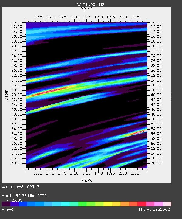
BIM Morne Bigot, Anses d'Arlets, Martinique - Earthquake Result Viewer
| Earthquake location: |
Near Coast Of Chiapas, Mexico |
| Earthquake latitude/longitude: |
14.8/-92.3 |
| Earthquake time(UTC): |
2019/02/01 (032) 16:14:13 GMT |
| Earthquake Depth: |
68 km |
| Earthquake Magnitude: |
6.6 Mww |
| Earthquake Catalog/Contributor: |
NEIC PDE/us |
|
| Network: |
WI West Indies IPGP Network |
| Station: |
BIM Morne Bigot, Anses d'Arlets, Martinique |
| Lat/Lon: |
14.52 N/61.07 W |
| Elevation: |
391 m |
|
| Distance: |
30.2 deg |
| Az: |
86.434 deg |
| Baz: |
274.466 deg |
| Ray Param: |
0.07929293 |
| Estimated Moho Depth: |
54.75 km |
| Estimated Crust Vp/Vs: |
2.09 |
| Assumed Crust Vp: |
5.88 km/s |
| Estimated Crust Vs: |
2.82 km/s |
| Estimated Crust Poisson's Ratio: |
0.35 |
|
| Radial Match: |
84.99513 % |
| Radial Bump: |
400 |
| Transverse Match: |
64.28383 % |
| Transverse Bump: |
400 |
| SOD ConfigId: |
3287751 |
| Insert Time: |
2019-02-15 16:32:18.872 +0000 |
| GWidth: |
2.5 |
| Max Bumps: |
400 |
| Tol: |
0.001 |
|

Signal To Noise
| Channel | StoN | STA | LTA |
| WI:BIM:00:HHZ:20190201T16:19:46.929996Z | 3.55528 | 1.4007921E-6 | 3.9400334E-7 |
| WI:BIM:00:HHN:20190201T16:19:46.929996Z | 1.0398867 | 5.48299E-7 | 5.2726807E-7 |
| WI:BIM:00:HHE:20190201T16:19:46.929996Z | 2.4552252 | 1.1796894E-6 | 4.8048116E-7 |
| Arrivals |
| Ps | 11 SECOND |
| PpPs | 27 SECOND |
| PsPs/PpSs | 38 SECOND |


