You are here: Home > Network List > 1E - GSC-BCOGC Induced Seismicity Study Stations List
> Station MONT4 Z > Earthquake Result Viewer
MONT4 Z - Earthquake Result Viewer
| Earthquake location: |
Komandorskiye Ostrova Region |
| Earthquake latitude/longitude: |
56.1/164.7 |
| Earthquake time(UTC): |
2023/10/26 (299) 16:05:11 GMT |
| Earthquake Depth: |
2.4 km |
| Earthquake Magnitude: |
5.9 Mww |
| Earthquake Catalog/Contributor: |
NEIC PDE/us |
|
| Network: |
1E GSC-BCOGC Induced Seismicity Study |
| Station: |
MONT4 Z |
| Lat/Lon: |
57.32 N/122.71 W |
| Elevation: |
1110 m |
|
| Distance: |
38.1 deg |
| Az: |
56.966 deg |
| Baz: |
299.905 deg |
| Ray Param: |
0.0757709 |
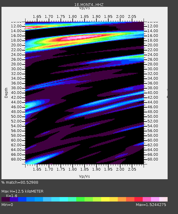
| Estimated Moho Depth: |
12.5 km |
| Estimated Crust Vp/Vs: |
1.60 |
| Assumed Crust Vp: |
6.232 km/s |
| Estimated Crust Vs: |
3.895 km/s |
| Estimated Crust Poisson's Ratio: |
0.18 |
|
| Radial Match: |
80.52988 % |
| Radial Bump: |
400 |
| Transverse Match: |
92.675255 % |
| Transverse Bump: |
141 |
| SOD ConfigId: |
31937991 |
| Insert Time: |
2023-11-09 16:07:11.122 +0000 |
| GWidth: |
2.5 |
| Max Bumps: |
400 |
| Tol: |
0.001 |
|

Signal To Noise
| Channel | StoN | STA | LTA |
| 1E:MONT4: :HHZ:20231026T16:12:00.900013Z | 2.4606352 | 4.1739816E-7 | 1.6963024E-7 |
| 1E:MONT4: :HHN:20231026T16:12:00.900013Z | 1.8826168 | 1.978526E-7 | 1.0509446E-7 |
| 1E:MONT4: :HHE:20231026T16:12:00.900013Z | 3.8820403 | 4.570922E-7 | 1.1774535E-7 |
| Arrivals |
| Ps | 1.3 SECOND |
| PpPs | 4.8 SECOND |
| PsPs/PpSs | 6.1 SECOND |


