You are here: Home > Network List > AK - Alaska Regional Network Stations List
> Station S31K Pelican, AK, USA > Earthquake Result Viewer
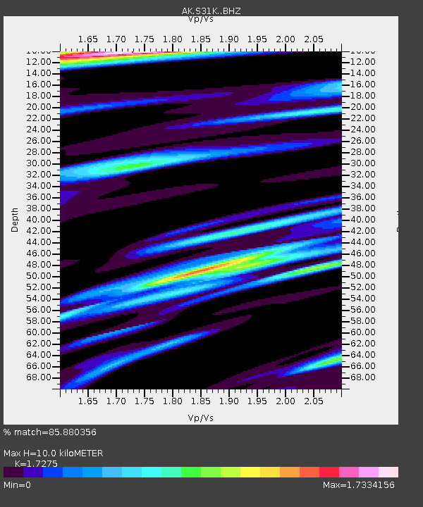
S31K Pelican, AK, USA - Earthquake Result Viewer
| Earthquake location: |
Komandorskiye Ostrova Region |
| Earthquake latitude/longitude: |
56.1/164.7 |
| Earthquake time(UTC): |
2023/10/26 (299) 16:05:11 GMT |
| Earthquake Depth: |
2.4 km |
| Earthquake Magnitude: |
5.9 Mww |
| Earthquake Catalog/Contributor: |
NEIC PDE/us |
|
| Network: |
AK Alaska Regional Network |
| Station: |
S31K Pelican, AK, USA |
| Lat/Lon: |
57.96 N/136.23 W |
| Elevation: |
34 m |
|
| Distance: |
31.3 deg |
| Az: |
61.561 deg |
| Baz: |
292.27 deg |
| Ray Param: |
0.07913558 |
| Estimated Moho Depth: |
10.0 km |
| Estimated Crust Vp/Vs: |
1.73 |
| Assumed Crust Vp: |
6.134 km/s |
| Estimated Crust Vs: |
3.551 km/s |
| Estimated Crust Poisson's Ratio: |
0.25 |
|
| Radial Match: |
85.880356 % |
| Radial Bump: |
262 |
| Transverse Match: |
67.964775 % |
| Transverse Bump: |
400 |
| SOD ConfigId: |
31937991 |
| Insert Time: |
2023-11-09 16:08:41.261 +0000 |
| GWidth: |
2.5 |
| Max Bumps: |
400 |
| Tol: |
0.001 |
|

Signal To Noise
| Channel | StoN | STA | LTA |
| AK:S31K: :BHZ:20231026T16:11:02.240009Z | 2.3172357 | 3.025266E-7 | 1.3055495E-7 |
| AK:S31K: :BHN:20231026T16:11:02.240009Z | 1.324827 | 1.476165E-7 | 1.11423226E-7 |
| AK:S31K: :BHE:20231026T16:11:02.240009Z | 2.1362112 | 2.2719748E-7 | 1.06355344E-7 |
| Arrivals |
| Ps | 1.3 SECOND |
| PpPs | 4.1 SECOND |
| PsPs/PpSs | 5.4 SECOND |


