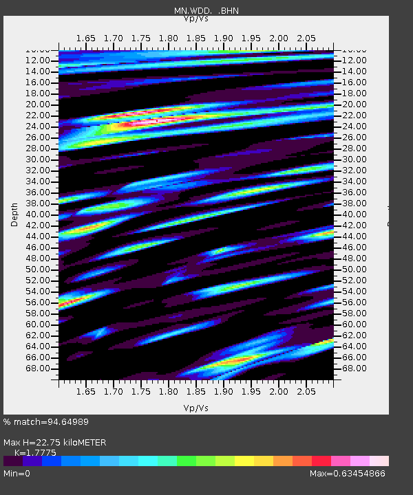
WDD Wield Dalam, Malta - Earthquake Result Viewer
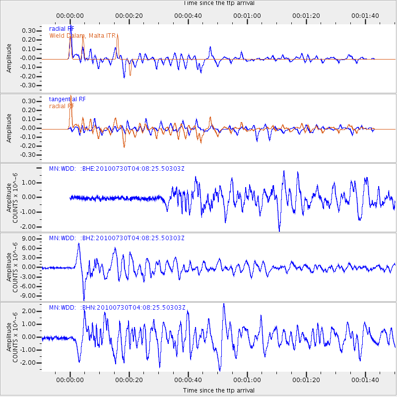
Earthquake location: Off East Coast Of Kamchatka
Earthquake latitude/longitude: 52.5/159.8
Earthquake time(UTC): 2010/07/30 (211) 03:56:13 GMT
Earthquake Depth: 23 km
Earthquake Magnitude: 6.1 MB, 6.3 MS, 6.3 MW, 6.3 MW
Earthquake Catalog/Contributor: WHDF/NEIC
Network: MN MEDNET Project
Station: WDD Wield Dalam, Malta
Lat/Lon: 35.87 N/14.52 E
Elevation: 41 m
Distance: 86.9 deg
Az: 332.431 deg
Baz: 20.387 deg
Ray Param: 0.043656845
Estimated Moho Depth: 22.75 km
Estimated Crust Vp/Vs: 1.78
Assumed Crust Vp: 4.05 km/s
Estimated Crust Vs: 2.279 km/s
Estimated Crust Poisson's Ratio: 0.27
Radial Match: 94.64989 %
Radial Bump: 400
Transverse Match: 90.09482 %
Transverse Bump: 400
SOD ConfigId: 319893
Insert Time: 2011-01-05 14:25:12.076 +0000
GWidth: 2.5
Max Bumps: 400
Tol: 0.001

Signal To Noise

ChannelStoNSTALTA
MN:WDD: :BHZ:20100730T04:08:25.50303Z31.972883.9998768E-61.2510218E-7
MN:WDD: :BHN:20100730T04:08:25.50303Z11.5947338.595418E-77.413209E-8
MN:WDD: :BHE:20100730T04:08:25.50303Z4.3858393.359874E-77.660732E-8
Arrivals
Ps4.4 SECOND
PpPs15 SECOND
PsPs/PpSs20 SECOND