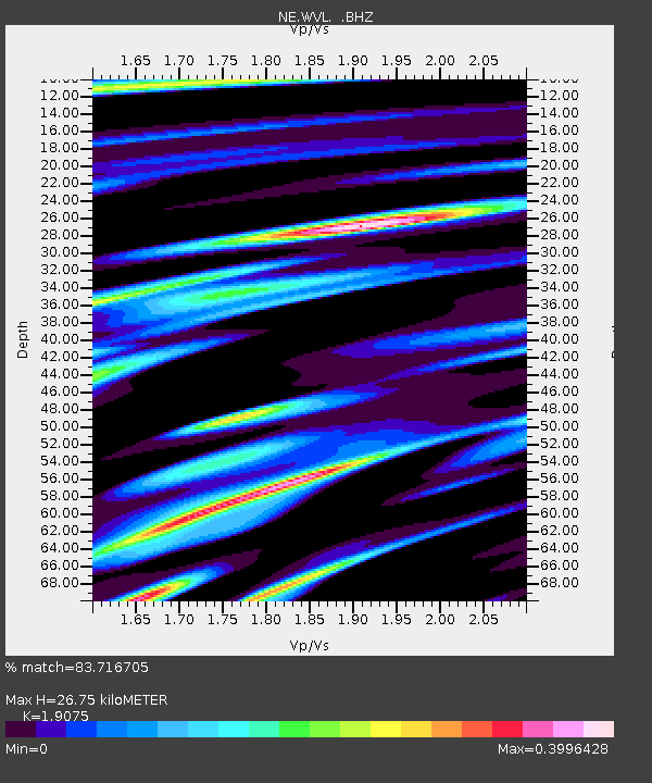
WVL Waterville, ME - Earthquake Result Viewer

Earthquake location: Off East Coast Of Kamchatka
Earthquake latitude/longitude: 52.5/159.8
Earthquake time(UTC): 2010/07/30 (211) 03:56:13 GMT
Earthquake Depth: 23 km
Earthquake Magnitude: 6.1 MB, 6.3 MS, 6.3 MW, 6.3 MW
Earthquake Catalog/Contributor: WHDF/NEIC
Network: NE New England Seismic Network
Station: WVL Waterville, ME
Lat/Lon: 44.56 N/69.66 W
Elevation: 85 m
Distance: 74.4 deg
Az: 34.364 deg
Baz: 331.134 deg
Ray Param: 0.05236014
Estimated Moho Depth: 26.75 km
Estimated Crust Vp/Vs: 1.91
Assumed Crust Vp: 6.419 km/s
Estimated Crust Vs: 3.365 km/s
Estimated Crust Poisson's Ratio: 0.31
Radial Match: 83.716705 %
Radial Bump: 387
Transverse Match: 71.59748 %
Transverse Bump: 400
SOD ConfigId: 319893
Insert Time: 2011-01-05 14:26:29.425 +0000
GWidth: 2.5
Max Bumps: 400
Tol: 0.001

Signal To Noise

ChannelStoNSTALTA
NE:WVL: :BHZ:20100730T04:07:18.235024Z9.0284823.718532E-64.118668E-7
NE:WVL: :BHN:20100730T04:07:18.235024Z8.3005081.0643828E-61.2823104E-7
NE:WVL: :BHE:20100730T04:07:18.235024Z2.62135827.2891027E-72.7806587E-7
Arrivals
Ps3.9 SECOND
PpPs12 SECOND
PsPs/PpSs16 SECOND