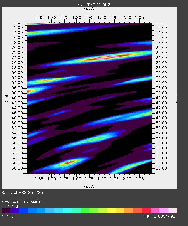
UTMT Martin, TN - Earthquake Result Viewer
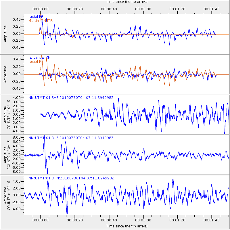
Earthquake location: Off East Coast Of Kamchatka
Earthquake latitude/longitude: 52.5/159.8
Earthquake time(UTC): 2010/07/30 (211) 03:56:13 GMT
Earthquake Depth: 23 km
Earthquake Magnitude: 6.1 MB, 6.3 MS, 6.3 MW, 6.3 MW
Earthquake Catalog/Contributor: WHDF/NEIC
Network: NM Cooperative New Madrid Seismic Network
Station: UTMT Martin, TN
Lat/Lon: 36.35 N/88.86 W
Elevation: 110 m
Distance: 73.3 deg
Az: 51.759 deg
Baz: 323.503 deg
Ray Param: 0.05308552
Estimated Moho Depth: 10.0 km
Estimated Crust Vp/Vs: 1.60
Assumed Crust Vp: 6.444 km/s
Estimated Crust Vs: 4.027 km/s
Estimated Crust Poisson's Ratio: 0.18
Radial Match: 83.857285 %
Radial Bump: 400
Transverse Match: 77.71514 %
Transverse Bump: 400
SOD ConfigId: 319893
Insert Time: 2011-01-05 14:27:50.874 +0000
GWidth: 2.5
Max Bumps: 400
Tol: 0.001

Signal To Noise

ChannelStoNSTALTA
NM:UTMT:01:BHZ:20100730T04:07:11.894998Z19.367313.951467E-62.0402769E-7
NM:UTMT:01:BHN:20100730T04:07:11.894998Z3.73211051.7610882E-64.718746E-7
NM:UTMT:01:BHE:20100730T04:07:11.894998Z2.76746651.3834238E-64.998882E-7
Arrivals
Ps1.0 SECOND
PpPs3.9 SECOND
PsPs/PpSs4.9 SECOND