You are here: Home > Network List > MB - Montana Regional Seismic Network Stations List
> Station FCMT Ford Creek > Earthquake Result Viewer
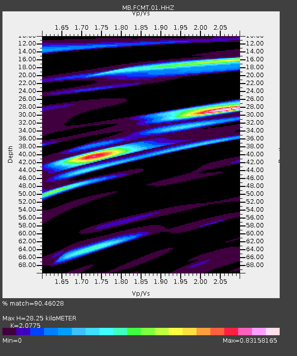
FCMT Ford Creek - Earthquake Result Viewer
| Earthquake location: |
Komandorskiye Ostrova Region |
| Earthquake latitude/longitude: |
56.1/164.7 |
| Earthquake time(UTC): |
2023/10/26 (299) 16:05:11 GMT |
| Earthquake Depth: |
2.4 km |
| Earthquake Magnitude: |
5.9 Mww |
| Earthquake Catalog/Contributor: |
NEIC PDE/us |
|
| Network: |
MB Montana Regional Seismic Network |
| Station: |
FCMT Ford Creek |
| Lat/Lon: |
46.46 N/110.86 W |
| Elevation: |
1836 m |
|
| Distance: |
50.5 deg |
| Az: |
63.069 deg |
| Baz: |
313.653 deg |
| Ray Param: |
0.06803485 |
| Estimated Moho Depth: |
28.25 km |
| Estimated Crust Vp/Vs: |
2.08 |
| Assumed Crust Vp: |
6.306 km/s |
| Estimated Crust Vs: |
3.035 km/s |
| Estimated Crust Poisson's Ratio: |
0.35 |
|
| Radial Match: |
90.46028 % |
| Radial Bump: |
297 |
| Transverse Match: |
81.80784 % |
| Transverse Bump: |
400 |
| SOD ConfigId: |
31937991 |
| Insert Time: |
2023-11-09 16:22:28.754 +0000 |
| GWidth: |
2.5 |
| Max Bumps: |
400 |
| Tol: |
0.001 |
|

Signal To Noise
| Channel | StoN | STA | LTA |
| MB:FCMT:01:HHZ:20231026T16:13:39.819996Z | 6.098679 | 6.6208503E-7 | 1.0856205E-7 |
| MB:FCMT:01:HHN:20231026T16:13:39.819996Z | 2.6861446 | 2.3530612E-7 | 8.759994E-8 |
| MB:FCMT:01:HHE:20231026T16:13:39.819996Z | 1.9693567 | 2.4142105E-7 | 1.2258879E-7 |
| Arrivals |
| Ps | 5.1 SECOND |
| PpPs | 13 SECOND |
| PsPs/PpSs | 18 SECOND |


