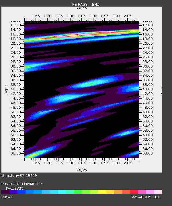
PAGS PA Geological Survey - Earthquake Result Viewer
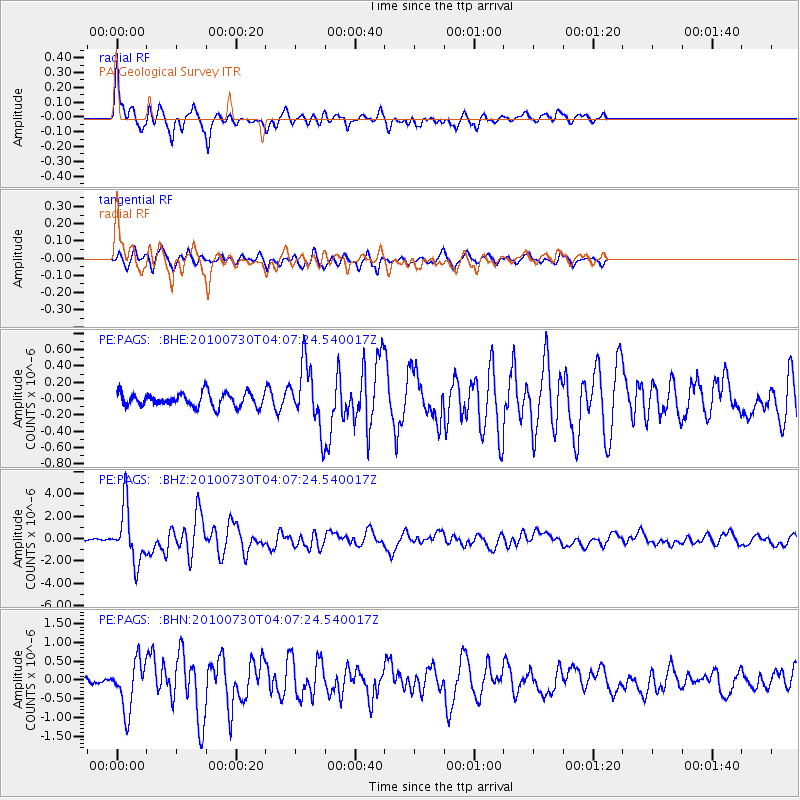
Earthquake location: Off East Coast Of Kamchatka
Earthquake latitude/longitude: 52.5/159.8
Earthquake time(UTC): 2010/07/30 (211) 03:56:13 GMT
Earthquake Depth: 23 km
Earthquake Magnitude: 6.1 MB, 6.3 MS, 6.3 MW, 6.3 MW
Earthquake Catalog/Contributor: WHDF/NEIC
Network: PE Penn State Network
Station: PAGS PA Geological Survey
Lat/Lon: 40.23 N/76.72 W
Elevation: 120 m
Distance: 75.5 deg
Az: 41.306 deg
Baz: 328.191 deg
Ray Param: 0.051633272
Estimated Moho Depth: 16.0 km
Estimated Crust Vp/Vs: 1.83
Assumed Crust Vp: 6.121 km/s
Estimated Crust Vs: 3.34 km/s
Estimated Crust Poisson's Ratio: 0.29
Radial Match: 87.29429 %
Radial Bump: 400
Transverse Match: 79.98022 %
Transverse Bump: 400
SOD ConfigId: 319893
Insert Time: 2011-01-05 14:28:29.242 +0000
GWidth: 2.5
Max Bumps: 400
Tol: 0.001

Signal To Noise

ChannelStoNSTALTA
PE:PAGS: :BHZ:20100730T04:07:24.540017Z20.728072.43435E-61.174422E-7
PE:PAGS: :BHN:20100730T04:07:24.540017Z4.82106836.5104206E-71.3504105E-7
PE:PAGS: :BHE:20100730T04:07:24.540017Z4.4569523.7515707E-78.4173465E-8
Arrivals
Ps2.2 SECOND
PpPs7.2 SECOND
PsPs/PpSs9.4 SECOND