You are here: Home > Network List > TM - Thai Seismic Monitoring Network Stations List
> Station PANO PANO staion > Earthquake Result Viewer
PANO PANO staion - Earthquake Result Viewer
| Earthquake location: |
Komandorskiye Ostrova Region |
| Earthquake latitude/longitude: |
56.1/164.7 |
| Earthquake time(UTC): |
2023/10/26 (299) 16:05:11 GMT |
| Earthquake Depth: |
2.4 km |
| Earthquake Magnitude: |
5.9 Mww |
| Earthquake Catalog/Contributor: |
NEIC PDE/us |
|
| Network: |
TM Thai Seismic Monitoring Network |
| Station: |
PANO PANO staion |
| Lat/Lon: |
17.15 N/104.61 E |
| Elevation: |
136 m |
|
| Distance: |
59.4 deg |
| Az: |
254.512 deg |
| Baz: |
34.433 deg |
| Ray Param: |
0.062263053 |
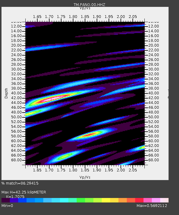
| Estimated Moho Depth: |
42.25 km |
| Estimated Crust Vp/Vs: |
1.71 |
| Assumed Crust Vp: |
6.498 km/s |
| Estimated Crust Vs: |
3.805 km/s |
| Estimated Crust Poisson's Ratio: |
0.24 |
|
| Radial Match: |
86.29415 % |
| Radial Bump: |
400 |
| Transverse Match: |
80.528206 % |
| Transverse Bump: |
299 |
| SOD ConfigId: |
31937991 |
| Insert Time: |
2023-11-09 16:32:07.900 +0000 |
| GWidth: |
2.5 |
| Max Bumps: |
400 |
| Tol: |
0.001 |
|

Signal To Noise
| Channel | StoN | STA | LTA |
| TM:PANO:00:HHZ:20231026T16:14:43.794971Z | 5.0067506 | 8.3629494E-8 | 1.6703348E-8 |
| TM:PANO:00:HHN:20231026T16:14:43.794971Z | 1.3045576 | 1.8069853E-8 | 1.3851327E-8 |
| TM:PANO:00:HHE:20231026T16:14:43.794971Z | 0.945504 | 1.4903739E-8 | 1.5762746E-8 |
| Arrivals |
| Ps | 4.8 SECOND |
| PpPs | 17 SECOND |
| PsPs/PpSs | 22 SECOND |


