You are here: Home > Network List > IU - Global Seismograph Network (GSN - IRIS/USGS) Stations List
> Station CTAO Charters Towers, Australia > Earthquake Result Viewer
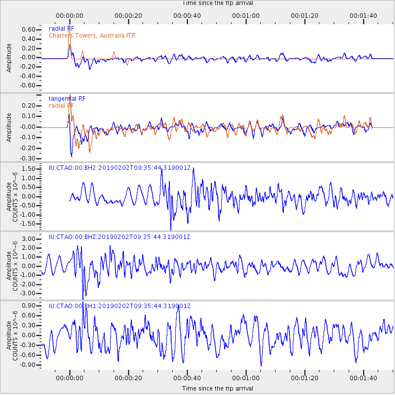
CTAO Charters Towers, Australia - Earthquake Result Viewer
*The percent match for this event was below the threshold and hence no stack was calculated.
| Earthquake location: |
Southern Sumatra, Indonesia |
| Earthquake latitude/longitude: |
-2.9/100.0 |
| Earthquake time(UTC): |
2019/02/02 (033) 09:27:34 GMT |
| Earthquake Depth: |
10 km |
| Earthquake Magnitude: |
6.1 Mww |
| Earthquake Catalog/Contributor: |
NEIC PDE/us |
|
| Network: |
IU Global Seismograph Network (GSN - IRIS/USGS) |
| Station: |
CTAO Charters Towers, Australia |
| Lat/Lon: |
20.09 S/146.25 E |
| Elevation: |
357 m |
|
| Distance: |
48.2 deg |
| Az: |
114.462 deg |
| Baz: |
284.705 deg |
| Ray Param: |
$rayparam |
*The percent match for this event was below the threshold and hence was not used in the summary stack. |
|
| Radial Match: |
71.546936 % |
| Radial Bump: |
400 |
| Transverse Match: |
66.07637 % |
| Transverse Bump: |
400 |
| SOD ConfigId: |
3287751 |
| Insert Time: |
2019-02-16 09:32:30.461 +0000 |
| GWidth: |
2.5 |
| Max Bumps: |
400 |
| Tol: |
0.001 |
|
Signal To Noise
| Channel | StoN | STA | LTA |
| IU:CTAO:00:BHZ:20190202T09:35:44.319001Z | 2.2703743 | 1.3637044E-6 | 6.006518E-7 |
| IU:CTAO:00:BH1:20190202T09:35:44.319001Z | 1.193866 | 3.9508015E-7 | 3.3092502E-7 |
| IU:CTAO:00:BH2:20190202T09:35:44.319001Z | 2.131309 | 7.159474E-7 | 3.3591908E-7 |
| Arrivals |
| Ps | |
| PpPs | |
| PsPs/PpSs | |


