You are here: Home > Network List > US - United States National Seismic Network Stations List
> Station MNTX Cornudas Mountains, Texas, USA > Earthquake Result Viewer
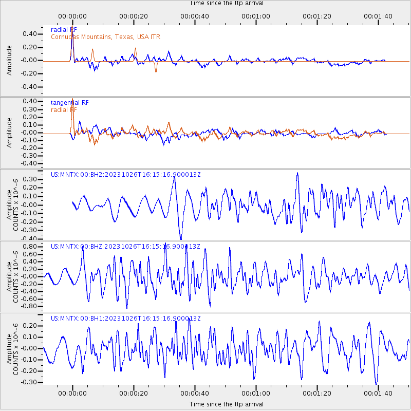
MNTX Cornudas Mountains, Texas, USA - Earthquake Result Viewer
*The percent match for this event was below the threshold and hence no stack was calculated.
| Earthquake location: |
Komandorskiye Ostrova Region |
| Earthquake latitude/longitude: |
56.1/164.7 |
| Earthquake time(UTC): |
2023/10/26 (299) 16:05:11 GMT |
| Earthquake Depth: |
2.4 km |
| Earthquake Magnitude: |
5.9 Mww |
| Earthquake Catalog/Contributor: |
NEIC PDE/us |
|
| Network: |
US United States National Seismic Network |
| Station: |
MNTX Cornudas Mountains, Texas, USA |
| Lat/Lon: |
31.70 N/105.38 W |
| Elevation: |
405 m |
|
| Distance: |
64.3 deg |
| Az: |
71.105 deg |
| Baz: |
321.489 deg |
| Ray Param: |
$rayparam |
*The percent match for this event was below the threshold and hence was not used in the summary stack. |
|
| Radial Match: |
74.35995 % |
| Radial Bump: |
400 |
| Transverse Match: |
64.14792 % |
| Transverse Bump: |
400 |
| SOD ConfigId: |
31937991 |
| Insert Time: |
2023-11-09 16:35:53.764 +0000 |
| GWidth: |
2.5 |
| Max Bumps: |
400 |
| Tol: |
0.001 |
|
Signal To Noise
| Channel | StoN | STA | LTA |
| US:MNTX:00:BHZ:20231026T16:15:16.900013Z | 2.3822052 | 3.0598707E-7 | 1.2844698E-7 |
| US:MNTX:00:BH1:20231026T16:15:16.900013Z | 1.9390543 | 1.2892383E-7 | 6.648799E-8 |
| US:MNTX:00:BH2:20231026T16:15:16.900013Z | 2.1418657 | 1.609227E-7 | 7.5132014E-8 |
| Arrivals |
| Ps | |
| PpPs | |
| PsPs/PpSs | |


